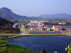
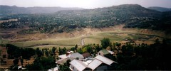
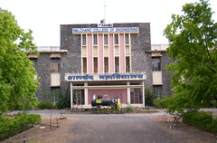
Adilabad is named after the Adil Shahi sultanate of Bijapur. It is the capital of Adilabad District, created in 1905 as an independent district. The district is part of the Telangana region. The town of Adilabad has a population of 108,000 people. This region has significant Marathi influence due to the proximity to the neighboring state of Maharashtra.
The capital of Adilabad District was shifted from Adilabad to Asifabad in 1913-14 and again reverted back to Adilabad in 1940-41. Earlier, the area was part of Sirpur-Tandur district, created in 1872 AD and it was called Edlabad.
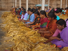
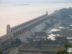
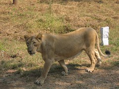
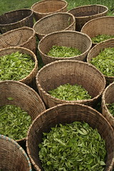
Encircled by mountains and lush green woods, Adilabad is rich in wildlife, invigorating rivers and gushing waterfalls. It is also a prosperous business destination. Adilabad is called the 'City of Cotton'. Because of an abundant supply of water, forest and cotton, the district is home to The Sirpur Paper Mills Ltd. Located in Sirpur Kagaznagar town of Adilabad, Sirpur paper is the pioneer paper industry in Andhra Pradesh. The paper mill was established in 1938 but commenced production in 1942 under the management of Hyderabad Constructions Co Ltd.
Anantapur city is the capital of Anantapur District in the state of Andhra Pradesh. It is also the hometown of the former President of India, Neelam Sanjeeva Reddy. Anantapur is largest district in Andhra Pradesh. It was carved out of the district of Bellary in 1882 AD. Now, it is part of the Rayalaseema region of Andhra.
Anantapur city has a population of 360,000 people and growing. It is one of the most backward provinces in the state, with very little rainfall. Anantapur has basically an agrarian economy.
World renowned religious preacher, Bhagvan Satya Sai Baba was born at Puttaparthy, Anantapur District on November 23, 1926. Vast number of devotees congregate at Anantapur from all over the world.
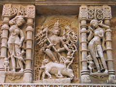
Known throughout the country for its silk trade, Anantapur is also famous for the Lepakshi temple and is a major tourist attraction. A wonderful example of Vijayanagar architectural style can be seen in the Veerabhadra Temple at Anantapur.
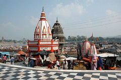
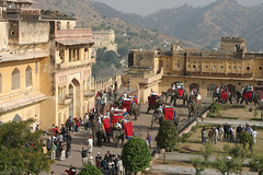
Tirupati, the abode of Lord Venkateshvara and Tirumala, the sacred hill, were considered so holy that non-Hindus were not permitted to visit here till 1870. The Pallavas of Kancheepuram, the Cholas of Thanjavur, the Pandyas of Madurai and the Kings of Vijayanagar were all devotees of Lord Venkateshvara and they all competed with one another in endowing the temple with rich offerings and contributions.
The town of Tirupati is one of the most ancient and spectacular places of pilgrimage in India. It is situated in the Chitoor district in southern Andhra Pradesh.
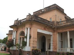
The town of Chittoor is the capital of Chittoor District in the southern state of Andhra Pradesh. The district is famous because of the Tirupati temple which is not only the richest temple in India but is visited by a quarter million visitors a day.
The city of 150,000 people is associated with N. Chandrababu Naidu, the former chief minister of Andhra. Chittoor is a major center for mangoes, grain, sugarcane and peanuts.
Nutrine Confectioneries, a major chocolate manufacturer in India, is located in Chittoor district. It is also home to Vijaya Milk Dairy. Chittoor has more than 60-70 major granite industries.
kadapa (Cuddapah), Kadapa District, Andhra Pradesh, India
Kadapa is the capital of Kadapa District in the Rayalaseema region of Andhra Pradesh. The city was called "Cuddapah" till August 19, 2005, when the name was changed to "Kadapa". Cuddapah was derived from the Telugu word "Gadapa" or the gate in English. The city is the gateway from north to the holy city of Tirupati.
Kadapa has a large Urdu speaking Muslim population but the primary language of the region is Telugu. Kadapa is better known as the home town of the Chief Minister, Y.S. Rajasekhara Reddy of Andhra Pradesh. The district of Kadapa is also famous for its "Black Cuddapah Stone" used extensively as slabs in Indian kitchens around the country.
The city was part of the Chola Empire for more than 300 years before it became a part of the Vijayanagar Empire in the later part of the 14th century. Muslims conquered Kadapa in 1565 AD and then the British took away the control from Nizam in 1800 AD. It was the British who formed the district if Cuddapah in 1808 AD with Siddavatam as the capital. In 1812 AD, the headquarters of the district was shifted to Kadapa.
The Kadapa District is rich in minerals and therefore has large cement factories like Bharat Cements, Coromandel Fertilisers, India Cements and Zuari Cements. Kadapa basin has large deposits of uranium. A uranium mining and processing plant is being established to recover 28,000 tonnes of identified uranium deposits. The district projects an economic growth of over nine per cent annually.
Kakinada & Rajahmundry, East Godavari District, Andhra Pradesh, India
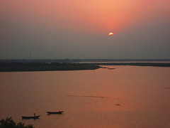
Kakinada city is the capital of East Godavari District, in the southern state of Andhra Pradesh. Kakinada is an important port city with a population of more than half a million people. It is also a large city but relatively a younger city compared to other important cities in the state of Andhra Pradesh.
Located at the top of the Godavari River delta, Rajahmundry is a major city in Andhra Pradesh with a population of 600,000 people. It was the first capital of any known Telugu Kingdom. The Chalukya ruler Rajaraja Narendra ruled this city around 1012. In the Middle Ages, it was called Raja Mahendravaram. It later became Rajahmundry during British rule.
Nannayya, the poet laureate, who was called 'Adi Kavi' (The first Poet) of Telugu belonged to this place. He, along with Tikkana and Yerrana, is responsible for the translation of Jaya, Sanskrit version of Mahabharata, into Telugu.
The district of East Godavari is located on the north-east coast of Andhra Pradesh. It covers a vast portion of Godavari River delta and therefore is rich in agriculture. East Godavari District is the most prosperous district in Andhra Pradesh.
The city of Guntur is not only the capital of Guntur District in Andhra Pradesh, but is also one of the larger cities of India. It has a population of 800,000 people and is called the' City of Spices'. The corporate headquarters of Tobacco Board of India is located in Guntur.
Guntur is the home of the famous Amaravati and Ancient Sitanagaram, rich in history culture and heritage. More recently, the region was under Nizam's rule prior to the colonial period. During the colonial rule, Guntur was under the control of French and then the British.
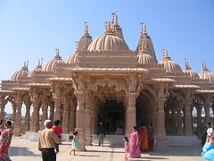
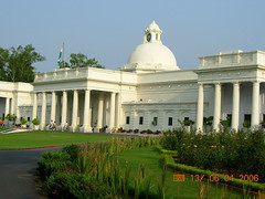
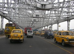
Situated in the Telangana region of Andhra Pradesh, Hyderabad is the 5th largest metropolis of India with a population of 6 million people. It is also one of the most developed cities in the country and is an emerging IT and biotech hub of India. It would be an obvious choice to show the famous Charminar in the picture to represent Hyderabad. But that would be unfair as this city is on the move. So we decided to feature the new film city of Hyderabad.
Hyderabad was founded in 1590 by Muhammad Quli Qutb Shah, Sultan of the Qutb Shahi Dynasty. Mughal Emperor Aurangzeb conquered Hyderabad in 1687 and this ended the rule of Qutb Shahi Dynasty. The Charminar was built by Muhammad Quli Shah in 1591.
Karimnagar city is the capital of the District of Karimnagar in the northern Telangana region of Andhra Pradesh. It is the fourth largest city in Telangana and is becoming a major business center.
Karimnagar is the land of Late Shri P. V. Narasimha Rao, former Indian Prime Minister and the father of The Modern India. Karimnagar derives its name from Syed Karimullah Shah Saheb Quiladar, and was a center of Vedic learning. Karimnagar is a district in Telangana region of Southern India.
Bhadrachalam, Khammam, Khammam District, Andhra Pradesh, India
Khammam is the capital of Khammam District in Andhra Pradesh. This new district was carved out of Warangal District on October 1, 1953. Bhadrachalam and Nuguru Venkatapuram talukas of East Godavari district were added to the Khammam District in 1959. The name Khammam is derived from the vertical rock hill, known as "Kamba" in the district of Khammam. The district has a population of over 2.5 million people.
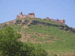
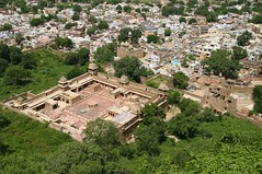
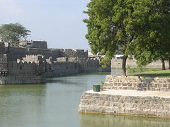
The foundation for the Khammam Fort was laid during the reign of Kakatiyas in 950 AD. But the construction and development of the fort continued for several centuries. The Fort, located on Stambhadri hill was further developed by the Reddi dynasty during fourteenth and fifteenth centuries and was subsequently taken over by the Qutb Shahi kingdom in 1531 AD. Khammam Fort represents both Hindu and Muslim architectural influences. The tall, pillar like stones, found in this hilly reign were used as pillars to support the ceiling of the structure.
The district of Khammam is rich in forest cover. Over fifty percent of the land area is covered by timber like Teak and other valuable varieties. Coal is plentiful in Kottegudam and Illendu areas. Large deposits of Marble Stone are also found in some parts of the district. Kottegudam Thermal Power Station supplies power to this district.
Bhadrachalam town is famous for the Sri Rama temple and is located amidst thick forest. The town is built on the banks of River Godavari. Bhadrachalam is about 120 kms from Khammam. The shrine is a pilgrimage site for Hindus and was built by Kancherla Gopanna popularly known as Bhakta Ramdas. Gopanna, a devotee of Lord Rama, built the shrine in 1630 AD.
Bhadrachalam Paperboards Ltd, an integrated paperboard manufacturing facility was setup by ITC Ltd. in 1975 in the district of Khammam. ITC Bhadrachalam employs 10,000 people and 2,000 of these live in a planned colony with all modern facilities integrated into the complex. It is the largest single paper manufacturing unit in India.
Situated on the Coromandel Coast of India, Machilipatnam was an important port for the French, British and the Dutch trade. It was the first trading post for the British East India Company, on the Coromandel coast. Machilipatnam (eyes of a fish) was hit by Tsunami in 2004.
Vijayawada, with a population of 825,000 people is the third largest city in Andhra Pradesh. The city is also known as the business capital of the state of Andhra. Located on the banks of Krishna River, Vijayawada is a center of Andhra culture.
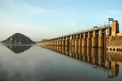
In 1959, the Prakasam Barrage was completed and a railway bridge was built on the Krishna River. These projects have helped the region expand its agricultural and commercial base. Vijayawada Railway Station is one of the busiest railway junctions in India.
Kurnool was the capital of the area now known as Andhra Pradesh for a brief period of 3 years. There are ruins of the kingdom of Vijaynagar dating back to 14th century. The place was called 'Kaandanavolu' before it became Kurnool.
Alampur, Mahbubnagar, Mahbubnagar District, Andhra Pradesh, India
Mahbubnagar city is the capital of Mahbubnagar District in the southern state of Andhra Pradesh. It is the largest district in Telangana Region and the second largest in Andhra Pradesh. Formerly known as "Palamooru", the name was changed to Mahbubnagar on December 4, 1890 AD, in honor of Mir Mahbub Ali Khan Asaf Jah VI, the then Nizam of Hyderabad. The district has a population of more than 3.5 million people, 90 percent of them speak Telugu and the rest 10 percent identify as Muslims or Urdu speaking people.
The town of Mahbubnagar is located only 96 kms southwest of Hyderabad and yet it is the most backward district in Andhra Pradesh. Even today the people of this region struggle for the basic needs of life. The agriculture activity is intensive and the groundwater resources are meager. Telangana region as a whole is short of water. Drought is ever persistent in Mahbubnagar District. Majority of the farmers are small and marginal.
Mahbubnagar is well connected by road rail and air with all important towns and cities in the State because of the proximity to the state capital. This transportation infrastructure was created during Nizam's period. The most important place of interest near Mahbubnagar is the famous 500 years old Banyan tree called "Pillalamarri". The site is 8 kms from the city and covers an area of three acres. The tree is visited by thousands of people and there is a shrine of a Muslim saint under the tree.
Alampur is another important destination located in Mahbubnagar District. Alampur is only 90 kms from Mahbubnagar city and is home to ancient Navabhramma temples. These nine temples are dedicated to Shiva. The Tungabhadra and Krishna rivers converge near Alampur. The entire district is covered under Krishna River Basin. The district is known for providing large numbers of human labour around the country. It is estimated that more than half a million people travel to far corners of the country for work.
Union Minister for Urban Development, S. Jaipal Reddy is a native of Mahbubnagar District.
Medak, Sangareddy, Medak District, Andhra Pradesh, India
Medak is a historic city, located in Medak District of Telangana region of Andhra Pradesh. It is a historic city, originally called Siddapur. Medak City is 100 kms north of Hyderabad. Medak has a citadel dating back to the Kakatiya Empire. The Fort was built on a hillock by Pratapa Rudra, the Kakatiya Emperor. It is a fine piece of architectural and military excellence.
Located in the heart of Andhra Pradesh, Nalgonda has a population of more than 100,000 people. The city has an average literacy rate of 78%, higher than the national average of 59.5%.
The name Nalgonda means Nalla(Black) + Konda (Hill). This city is hill locked between two hills KaapuRaala Gutta and Lateef Shahi Gutta. Gutta in Telugu means hill.
Situated on the south and north banks of Pennar River, Nellore is an emerging city of 700,000 people in the State of Andhra Pradesh. The city attracts a lot of immigrants from other parts of the country because of the flourishing aquaculture industry and paddy cultivation. The Flamingo Festival is celebrated in this district's famous bird sanctury at Nelapattu.
Formerly a part of the composite Madras State, Nellore district came under Andhra Pradesh, when the States were re-organized on a linguistic basis on November 1, 1956. Potti Sriramulu, a Telugu patriot and activist, fasted to death for the formation of Andhra State within the Indian Union.
Nizamabad, Nizamabad District, Andhra Pradesh
Formerly known as Indur or Indrapuri, Nizamabad is located in the Telangana Region of Andhra Pradesh. A city of 365,000 people was ruled by Rashtrakutas in the 8th century. The city was named after the King "Indra Vallabha Panthya Varsha Indra Som". A railway line was constructed between Secundrabad and Manmad in 1905. The railway station was named after the Nizam and was called Nizamabad. The city also came to be known as Nizamabad for "Nizam-ul-Mulk".
A major center for tobacco trading, Ongole is a small town in the State of Andhra Pradesh. The city has a population of 150,000 people most of whom are employed in the granite mining, stone cutting and polishing industry.
Ongole is famous for its Ongole breed of oxen which are considered virile and of superior stock. They are one of the major Zebu cattle breeds of the world.
There is a very old Lord Shiva temple in the town.
The name "Ongole" is derived from Omgole, roughly translated as submitting to Shiva.
Rangareddy District, Andhra Pradesh, India
Rangareddy District encircles the city and the district of Hyderabad. This district is named after the famous freedom fighter and Telanga leader, Ranga Reddy.
A town of 100,000 people, Srikakulam is located on the banks of Nagavali River in the coastal district of Andhra Pradesh. Since it shares a border with the east Indian State of Orissa, a significant number of people can understand and even communicate in Oriya. The primary language of Srikakulam is Telugu.
The second largest city in Andhra Pradesh with a population of over 2 million people, Vishakhapatnam has India's largest shipbuilding yard. The city, popularly known as Vizag, has a giant steel plant and a large fertilizer factory. The area has large deposits of minerals.
A tiny humble fishing village, became a part of the powerful Kalinga Empire that was conquered in a bloody war by the Emperor Ashoka in 260 BC. After the conquest, Ashoka was so shaken by the violence that he renounced war and eventually became a non violent Budhist.
The town was originally under the rule of the Kalinga Empire, and later came under the rule of the Gajapati, Telugu, and Qutb Shahi empires. Around 1450, Appalaraju began to rule the region under the Nawab of Arcot, with Anakapalle as his fortified headquarters. When the British took control of the area in 1803, local leaders were poisoned or hung.
Anakapalle is a small town in Visakhapatnum district of Andhra Pradesh, with a population of only 85,000 people. It is the largest source of Gur (jaggery) in southern India.
Rulers of this Zamindari belong to the Pusapati family. The village Pooshpadu in Nandigama Taluq was built by Amala [Raju]]. The village later came to be known as Pusapadu. Therefore, the Kshatriyas living there came to be known as Pusapati.
In 1754, Pusapati Vijayarama Gajapathi Raju, of the ruling family of Vizianagaram, made an alliance with the French, but a few years later the territory was ceded to the British. It remained under their control until independence in 1947.
The population of the city is estimated to be around 175,000 people.
Located in Telangana region of Andhra Pradesh, Warangal is the fourth largest city in the state, with a population of more than a million people. The city serves as a major urban center for the backward Telangana region. Warangal is well known for granite quarries.
Warangal was the capital of a Hindu Shaivite kingdon ruled by the Kakatiya dynasty from 12th to the 14th centuries. Kakatiya rule ended in the 14th century, when Warangal was conquered by the Muslim-ruled Bahmani Sultanate. Later, Golconda sultanate ruled Warangal.
Eluru, West Godavari District, Andhra Pradesh, India
Eluru is the state capital of West Godavari District in the southern state of Andhra Pradesh.
As the town of Eluru was built up very near to the ancient capital of Vengi it has got many historical monuments in and around it. Muslims who brought stones from the temples at Vengi built the Fort of Eluru.
Itanagar is situated at the foothills of Himalayas and is the capital of Arunachal Pradesh. The Nishi, also known as the Nishing, is the major tribe in Itanagar area. The city is named after the Itafort which dates back to the 15th century.
A beautiful yellow roofed Buddhist temple reflects the Tibetan influence and provides good view of Itanagar and the surrounding areas.
The gateway to the north-east part of the country, Guwahati is close to Dispur, the capital of the Indian state of Assam. The city is between the southern bank of Brahmaputra river and the foothills of the Shillong plateau. Guwahati was situated midway between two powerful kingdoms, the Ahom and the Koch kingdoms.
Today Guwahati is important because it is the commercial center of Assam and is also the hub that connects six other northeastern states of Arunachal Pradesh, Nagaland, Manipur, Mizoram, Meghalaya and Tripura. The city has a population of over 2.5 million people. The picture is of the Indian Institute of Technology, Guwahati.
Located on the Southern bank of Ganges, the modern city of Patna is the capital of the Indian State of Bihar. A bustling city of 1.2 million people, Patna was the famed Patliputra, the seat of power and nerve center of the sub-continent. From Patliputra, the mighty emperor Chandragupta Maurya ruled a vast empire, stretching from Bay of Bengal to Afghanistan. Early Mauryan Patliputra was mostly built with wooden structures. Emperor Ashoka, the grandson of Chandragupta Maurya, transformed the wooden capital into stone construction around 273 BC.
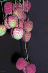
Muzaffarpur is famous for Litchis, a fruit found only in a few places in the world. This city is also known for a medical collage and an engineering collage. Muzaffarpur is a leading center of education and boasts of one of the oldest unversities of North Bihar.
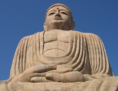
Bodh Gaya complex is located about 96 kilometers from Patna in the state of Bihar. It contains Mahabodhi Temple, built over 2,500 years back, and is the place of Buddha's Enlightenment. Bodh Gaya is the most important pilgrimage site for Buddhists.
Prince Gautama Siddartha (Gautama Buddha), wandering as a monk, reached the banks of Falgu River near the city of Gaya. There he sat in meditation under a peepal tree and after three days and nights of meditation, Siddharta (Buddha) attained enlightenment.
Situated on the banks of Falgu River, Gaya is a place sanctified by both Hindu and the Buddhist religions. It was part of the ancient Magadh.
Documented history of Gaya dates back to the birth of Gautam Buddha. About 15 km from Gaya town is Bodh Gaya, the place where Lord Buddha got enlightenment.
Bhagalpur silk is well-known in India and abroad. The silk production in the city is hundreds of years old and a whole community exists that has been producing silk for generations. Bhagalpur has a silk institute to preserve this craft.
The city is located on the southern banks of Ganga river in the eastern state of Bihar. The snake queen (Nageen) is worshiped during "Vishaili Puja" and the tradition goes back hundreds of years.
Raipur is the capital of the newly created State of Chhattisgarh. It was formarly a part of Madhya Pradesh. Located to the west of Mahanadi River, Raipur has a population of 600,000 people.
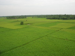
The city of Raipur is located near the centre of a large plain, sometimes referred to as the “rice bowl of India” - where hundreds of varieties of rice are grown.
The airport in Raipur is situated in the outskirts of the city, in the village of Mana. The airport is popularly known as Mana Airport. It is the sole commercially operating airport of Chattisgarh state.
The city of Bhilai Steel Plant is the second-largest in Chhattisgarh, with a population of over half a million people. The city is only 40 km from the state capital, Raipur. Amil Sana of Indian Idol fame hails from Bhilai.
Formerly a small town, Bhilai grew rapidly after the construction of one of the biggest steel plants in the country. The pace of development has increased since the formation of Chhattisgarh as a seperate state.
Bilaspur town with a population 250,000 people is located on the banks of Arpa River, in the newly created state of Chhattisgarh. The town is known for its tasty and aromatic Doobraj rice and handloom woven colorful soft Kosa silk sarees.
Bilaspur is developing as a center of education for Chhattisgarh. Students from all over the state come to study engineering, medicine and administrative officers' competitive exams.
The downtown is called Goal (round) Bazaar and Sadar Bazaar.
Delhi is the national capital of India with a population of more than 15 million people. Pandavas founded Indraprastha around 5,000 BC. Delhi is believed to be the site of Indraprastha. Delhi is probably one of the fastest growing cities in the world.
The Baha's Lotus Temple, the growing Delhi Metro and the imposing Swaminarayan Akshardham Temple are the new landmarks in Delhi.
New Delhi, the capital of independent India, is not even a hundred years old. Delhi (old Delhi) on the other hand has been the historic capital of the subcontinent for hundreds of years. Much of New Delhi was planned by Sir Edwin Lutyens, who laid out a grandiose capital of the Raj to be shifted from Calcutta to Delhi. The reason for the new capital was the coronation of King George V in 1911. The scale and magnificence of New Delhi was not unlike Washington DC or Paris.
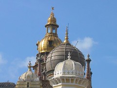
Delhi is a spacious, open city that houses many government buildings and embassies, apart from places of historical interest. Notable attractions in New Delhi include the Rashtrapati Bhawan, the one-time imperial residence of the British Viceroys; the India Gate, a memorial raised in honour of the Indian soldiers martyred during the Afghan and subsequent wars; the Laxminarayan Temple, built by the Birlas, one of India's leading industrial families; The Swaminarayan Akshardham temple; Humayun's Tomb, the Purana Quila, built by Humayun, with later-day modifications by Sher Shah Suri Tughlaqabad; Delhi's most colossal and awesome fort, (Qutab Minar), built by Qutb-ud-din Aybak of the Slave Dynasty; and the lotus-shaped Bahá'í House of Worship.
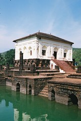
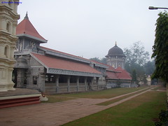
Ponda is located in the central part of Goa. It is right on top of the Panjim-Bangalore highway. Safa Masjid, a well-preserved Mosque, built in 1560 by the Bijapuri ruler Ibrahim Adil Shah is here. It is a remarkable Mosque because it is one of two Islamic shrines that escaped the Portuguese Inquisition in Goa. There are also many Hindu temples in the area, the most famous being the Mahalasa, Shantadurga, Mangesh and Navadurga temples. Ponda is very close to the town of Farmagudi. Government Engineering College of Goa is in Farmagudi part of Ponda town. Ponda is well connected by road to the Panaji (Capital of Goa) and main railway junction Madgaon. Ponda is industrial centre of Goa state.
Verna Goa is located on the west coast of India, in the Konkan region, bounded by Maharashtra in the north and Karnataka in the south and east. It was part of the Portuguese overseas territory that existed for 450 years. India reclaimed it in 1961.
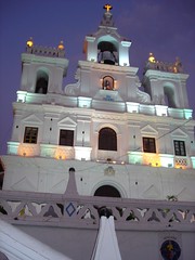
Panaji (Panjim) is the capital of the Indian State of Goa with a population of 65,000 people. It is the third largest city of Goa, after Vasco and Madgaon. In 1843, the city was renamed Nova Goa, when it officially replaced the city of Goa (now Old Goa) as the administrative seat of Portuguese India, though the viceroy had already moved there in 1759.
Incorporated into India in December 1961, Panaji became a state capital on Goa's elevation to statehood in May 1987. The heart of the city is the Church Square with the Portuguese Baroque "Our Lady of the Immaculate Conception" Church built in 1541.
Vasco da Gama, 29-km by road southwest of Panjim, sits on the narrow western tip of the Marmagoa (also known as Mormugao) peninsula, overlooking the mouth of the Zuari River. Acquired by the Portuguese in 1543, this strategically important site was formerly among the busiest ports on India's west coast.
Goa Velha, comes forth as a key Portuguese stronghold in Goa. It is also considered as the second capital of Bijapur kingdom with the exquisite Sultan's Palace acting as a timely reminder of the deep history attached to it.
Birthplace of Mahatma Gandhi, Porbandar is a coastal city in the Indian State of Gujarat. It is an important all-weather port on the Arabian sea. Porbandar is a deep sea port built during the last quarter of the 20th century. It is a tourist center because of its association with Mahatma Gandhi. Porbandar is served by train line and an airport.
The Jethwa clan of Rajputs ruled over the princely State of Porbandar during the middle of 16th century. The state was subordinate to the Mughal Governor of Gujarat. The Marathas overthrew the rulers in the later half of the 18th century. First the Gaekwads of Baroda and then the Peshwas took over the control till the British excercised their influence in 1807.
Rajkot was founded by the Jadeja Clan in 1612. It became the capital of Saurashtra State after independence. When the Indian States were reorganized on linguistic basis, Rajkot was merged into newly formed Gujarat State. Mahatma Gandhi spent his early years in Rajkot while his father was a Diwan to one of the Nawabs of Saurashtra.
The city of Rajkot hosts several small scale manufacturing units. It is well known for forging and casting industry as well as some auto parts. Rajkot is famous for Bandhani Sarees, mirror work and silk embroidery.
The city of former Prime Minister of India, Morarji Desai, Valsad is a city located in the southern most part of Gujarat state. Valsad is well known for its Alphonso (Haapus) mangoes and still retains this business as one of the main segments of its economy. The city has a population of 1.4 million people.
Nawanagar (new town) was established by the legendry Jam Rawal on the coast of Gulf of Kutch in August 1540 AD. His father Jam Lakhaji ruled Terabanu in Kutch. But for the ongoing fued with his cousins, Jam Rawal decided to leave Kutch and descended on the coast of Kathiawar in 1535 AD.
Nawanagar eventually came to be known as Jamnagar in the memory of Jam Rawal. It is called the "Jewel of Kathiawar". Jamnagar has unspoilt beaches, forests and fascinating bird santuaries. Today, the 200 km long coast is known for it's industries. Reliance, Essar and Tata are some of the industrial giants in the region.
The old walled city of Bhuj is the capital of Kutch district in Gujarat. The former native state of Kutch was established by Rao Khengarji I in 1549. In ancient times, the gates of the city were locked at night.
Gujarat Earthquake in 2001 destroyed much of the town including the Bhuj Palace. The epicenter of the 6.9 magnitude earthquake was near the city of Bhuj.
Jivaraj Mehta, the first Chief Minister of Gujarat , was from this city. Amreli was part of Baroda state under Gaekwads during the nineteenth century. After independence, the district became part of Bombay State and a separate district in Gujarat State after the bifurcation of Bombay State.
The birth place of Jamshedji Tata, founder of the Tata Corporate Empire in Navsari city is located in the State of Gujarat. The Parsi-Zoroastrian community arrived here in the 12th century and changed the history of Navsari for ever. The district has a population of 1.25 million people.
When movies started talking, Jehangir Talkies was built to mark the occasion. The city of Navsari is renowned for diamond polishing business. The Navsari's port has been written about for the past 2,000 years. The true prosperity for Navsari came during Gaikwad's rule as he laid down the infrastructure of today's modern Navsari.
Surat is called the diamond city and is home to 3.6 million people. Located on the left bank of Tapti River, the city is largely known for its textile and diamond business. Three-quarters of the world's diamonds are cut and polished here.
In 2006, city saw a devastating flood and the water level reached more than 20 feet in some parts of the city. Nearly 80 percent of the entire city was under water.
There are more than 3,000 pictures of Ahmedabad on Flickr. This is the closest one that can represent this important city of 5.2 million people. Gujarati food is one of the best vegetarian foods that India offers. It is not easy to find food like this in the entire United States.
Located on the banks of Sabarmati River, Ahmedabad was the capital of Gujarat from 1960 to 1970, till it was moved to Gandhinagar. It is the largest city in Gujarat and the seventh largest city in India.
The Gulf of Khambhat (formerly known as the Gulf of Cambay) is an inlet of the Arabian Sea along the west coast of India, in the state of Gujarat.
The Gulf of Khambhat has been an important center of trade since ancient times; its ports connect central India to the maritime trade routes of the Indian Ocean. Bharuch (Broach), Surat, Khambhat, Bhavnagar, and Daman are historically important seaports. Bharuch has been important since ancient times; Khambhat was the gulf's chief port in the Middle Ages, but after the silting of its harbor, Surat rose to prominence as the most important harbor of the Mughal empire.
The land of the 'Iron Man of India', Sardar Vallabhbhai Patel, Nadiad is a medium-sized city of 300,000 people. Located in Kheda district, the city is famous for Santram Mandir, and for its carvings. Nadiad also boasts the Dharamsinh Desai Institute of Technology, which is famous in Gujarat for its quality education in the fields of engineering and technology. Nadiad is situated on the Banks of Shedhi River.
The city was formerly ruled by the Muslims, and later by the Gaekwad of Baroda. Malhar Rao Gaekwad built the 1st Hindu temple called Narayan Dev Mandir, located in the center of the city.
Palanpur was the seat of a princely state ruled by the Lohani clan of Afghans. While the earlier history of the family is obscure, the family has apparently lived in India since at least the 16th century; a forbear of the family is reputed to have wed the foster-sister of the mughal emperor Akbar and received Palanpur and surrounding areas as dowry. However, the family comes into historical prominence during the period of instability that followed the demise of Aurangzeb in the early 18th century. It was overrun soon afterwards by the Marathas; the Lohanis followed the trend of seeking recourse in the HEIC against them and finally entered the subsidiary-alliance system in 1817, along with all other neighbouring states.
The district of Surendranagar has a population of over 1.5 million people. It is basically an agrigarian society with cotton as its main crop. The city is a commercial center for salt production. Surendranagar also has ceramics industry as a major employer in the region.
Dwarka, Gujarat
Located in the Jamnagar district of Gujarat, Dwarka is one of the most ancient cities in India. Lord Krishna is believed to have renounced war in Mathura for the greater good and decided to settle down in Dwarka.
Dwarka was a planned city on the banks of Gomati River. After Krishna left for heavenly abode, Arjuna went to Dvaraka (Dwarka) to bring Krishna's grandsons and the Yadava wives to Hastinapur. After Arjuna left Dwarka, it was submerged in the sea.
The recent underwater studies conducted by the Archeological Survey of India reveals the existence of a city dated back to the 2nd millennium BC.
A former princely state of British India, Junagadh was ruled by Nawab Mahabat Khanji and his muslim ancestors since the time of Mehmood Ghaznavi. The Nawab decided to join Pakistan after the partition and plunged the region in financial crisis. He was forced to flee to Karachi and the Dewan of Junagadh, Sir Shah Nawaz Bhutto (father of Zulfiqar Ali Bhutto) took charge and invited the Government of India to intervene. A plebiscite was held in which only 91 voters sided with Pakistan. India assumed control over the entire state of Junagadh in February 1948.
Gandhinagar, Gujarat
The capital of Gujarat State, Gandhinagar is the second planned city in India after Chandigarh. It is probably the only state capital designed and planned by Indian Town Planners - H. K. Mewada and P. M. Apte.
The new city is spread on the banks of Sabarmati river and is named after Mahatma Gandhi. Gandhinagar is considered the 'greenest' city in India.
Mahatma Gandhi started his first Satyagraha in Keda, Gujarat in 1918. The peasants mostly owned their lands and were economically better-off than their counterparts in other parts of the country.
A famine struck the district and virtually destroyed the agrarian economy. The British government demanded full taxes and a 23 percent increase. Gandhiji proposed Satyagraha (a non-violent, mass civil disobedience), to revolt against gross tyranny.
Vadodara or better known as Baroda, has a population of 1.7 million people. It is the third biggest town in Gujarat after Ahmedabad and Surat. Vadodara is one of the most cosmopolitan cities in India and therefore is considered the cultural capital of Gujarat.
The city of Vadodra was conquered by Maratha leader, Pilaji Gaekwad, in 1721 from the Mughals. The Peshwa (nominal leader of the Marathas) recognized the Gaekwads rule over Vadodara. After the defeat of Marathas in 1761 by the Afghans, the Gaekwads consolidated their control over Vadodara. In 1802, the British signed a treaty with the Gaekwads and recognized The Maharaja of Baroda.
Godhra and Dahod are the twin cities in the state of Gujarat. Dahod is the birthplace of mughal emperor Aurangzeb and Godhra is the location of the Godhra riots in 2002.
Godhra has about an equal number of Hindus and Muslims and is a "communally sensitive" town.
Patan is an ancient fortified town, founded in 745 by Vanraj Chavda, the most prominent King of the Chavda Kingdom. He named the city Anhilpur Patan after his close friend and Prime Minister Anhil. Patan enjoyed a privileged status of capital of Gujarat, for about 600 years from 745 to 1304 under Hindu Rulers. The major Rajput clans of Chavdas (746-942), Solankis (942-1244) and Vaghelas (1244-1304) ruled the Hindu Kingdom of Gujarat from Patan.
These Chalukya Rajputs, with Paramaras of Malwa, the Chauhans of Sakambhari and Chandellas of Kalanjar and Mahoba, were serious contestants for supremacy in Northern India. At the zenith of their imperial greatness, the bounds of Gujarat were extended to cover Saurashtra and Kutch in the West, Lata in the South, Malwa in the East and Southern Rajasthan in the North.
This small village in southern Gujarat was known as Bhrigu Kaksha in olden days. It was the domain of Bhrigu, an ancient sage. It was here, on the banks of river Narmada, that the celebrated Asura King Mahabali conducted a great sacrifice. In this sacrifice, came a Brahmin boy named Vamana, who interfered with the King's sacrifice and put an end to his reign. A sage named Guru Shukracharya, in the lineage of Bhrigu, was the priest of King Mahabali.
Water is scarce in Gujarat but never in Bharuch because of its location on the Narmada River. Bharuch has always been prosperous because of agriculture and other linked commercial activities.
Hisar, formarly spelt as Hissar, was founded by Firoz Shah Tughlaq in 1354 A.D. It was originally called Hissar-e-Firoza. There is evidence of pre-Harappan settlements in this area. Excavations of Agroha, Banawali and Kunal found the coins of Kushan Kings. The presence of the pilar in the Hisar fort belonging to the time of Emperor Ashoka (234 BC) was originally from Agroha.
The city of Hisar is one of the important and fast growing urban centers of Haryana. Hisar also played an important role during the freedom struggle. The city also produced important political leadres.
This town was probably called Guru Gram or Guru Gaon as per some stories in Mahabharata. However it certainly is one of the fastest growing cities in Haryana. It is home to Maruti Suzuki, the largest Indian automaker.
Ambala is part of the green state of Haryana. Majority of the population is Punjabi speaking but still a unique state. Ambala has been a very important army and air-force base but also one of the bread baskets of the Indian union.
Founded by Shaikh Farid, treasurer of Jahangir in 1607. Faridabad is famous for Henna production and Suraj Kund Mela. It is also a major industrial city in the state of Haryana.
The city was designed by the French architect Le Corbusier in 1950s. Chandigarh was created to replace Lahore as the capital of undivided East Punjab, India. Pending the construction of a new capital for Haryana, Chandigarh works as a joint capital for Punjab & Haryana
Located in Kangra valley, it became the capital of Kangra District in 1852. A popular hill station for the British, Dharamsala has been connected with Buddhism for a long time. In 1905, the area was devestated by a massive earthquake.
The small town of Manali has a population of only 30,000 people. Manali is believed to have been named after Manu (Adam) and the word Manali literally means 'the abode of Manu'. The Manali village has a temple dedicated to Manu.
Kasauli is one of the small towns developed by the British at a towering height of 6,000 feet above the sea level. Surrounded by pine forests, Kasauli is a good detour between Shimla and Kalka. The 19th century colonial ambience is obvious by the look of cobbled paths, quaint shops, gabled houses with beautiful facades.
Kasauli is one of the small towns developed by the British at a towering height of 6,000 feet above the sea level. Surrounded by pine forests, Kasauli is a good detour between Shimla and Kalka. The 19th century colonial ambience is obvious by the look of cobbled paths, quaint shops, gabled houses with beautiful facades.
Chamba town is 1,000 years old. The capital of Chamba kings, this town was founded by Raja Sahil Varman. The valley is adorned with highly fragrant Champaka trees. Champavati is worshipped as a goddess in Chamba.
The city of Shimla is located at an altitude of 6,500 feet in the mid-western ranges of the Himalayas. This region is full of evergreen pine forests and is a popular hill station of India. Shimla is the capital of the State of Himachal Pradesh. Under the British, it was the summer capital of India.
Charles Kennedy, a Scottish civil servant, built Shimla's first British summer home in 1822. By the middle of the 19th century, Shimla was established as the hallmark of the British rule in India. The Kalka-Shimla rail link, bears testimony to the engineering excellecne of the British.
Dharampur, an erstwhile state, is located in scenic Himachal Pradesh, on the banks of the Swaragavahini River. The town is on the national highway between Chandigarh and Shimla.
The city of Srinagar was established by King Pravarasena II over 2,000 years ago. Srinagar was also a part of the Maurya Empire. Ashoka introduced Buddhism to the Kashmir valley. The Hindu and the Buddhist rule came to an end during 14th century, when the Kashmir valley, including the city of Srinagar, came under the control of Muslims and then the Mughal rulers.
Srinagar has a population of close to a million people and it lies on both banks of the Jhelum River, a tributary of the Indus River.
Leh Ladakh, Jammu & Kashmir
For most of its existence, Ladakh was an independent kingdom. Since 1531, it faced constant incursions from the muslim rulers of Kashmir. Finally, it was annexed to Kashmir in 1850s.
Leh, the capital of Ladakh is located at a height of 3,500 meters. It is also the center of Tibeto-Buddhist culture.
Jammu city is the winter capital of the State of Jammu & Kashmir. Jammu was founded by Raja Jamboolochan in 14th century BC. During one of his hunting expeditions, he reached the Tawi River where he saw a goat and a lion drinking water together at the same place. The King was so impressed with the harmony that he decided to set up a town after his name, Jamboo. With time, the name became Jammu.
Jammu is the only region in the State of Jammu & Kashmir where there is a Hindu majority population. 65% of these Hindus are Dogras. The rest 24% are Muslims and 4% Sikhs.
Jamshedji Nusserwanji Tata founded the city of Jamshedpur in 1919. Located in the East Singhbhum district of the newly created state of Jharkhand, it is surrounded by the beautiful Dalma Hills. The rivers, Subarnarekha and Kharkhai border the north and west of the city.
Jamshedpur is a modern industiral city with a robust infrastructure and a strong industry. The largest factory in the area is Tata Iron & Steel Company and it is situated right in the center of the city.
Once the summer capital of Bihar, Ranchi is the capital city of newly created State of Jharkhand. It has a cool climate and since the creation of the a separate state for the tribal regions of South Bihar, the city has witnessed a 50% growth in population. With a current population of 1.5 million people, Ranchi has seen rising employment opportunities and opening of numerous regional and state-level banks and corporate companies. The city is becoming a cosmopolition capital of Jharkhand.
The town of Shimoga is located on the banks of Tunga River. It is an important industrial and commercial center now in the State of karnataks. Shimoga District has a population of 1.6 million people and is considered the heartland of Kannada language and culture.
Shimoga District is mostly dependent on its rich agricultural pastures for income. Paddy is the most commonly grown produce. Tourism to Jog falls, Balligavi, Gudavi, Ikkeri, Keladi and Banavasi are the second main cash earners. Handicrafts from Sagara and Soraba also bring in some income.
Chitradurga features bold rock hills and picturesque valleys, huge towering boulders in unimaginable shapes. It is known as the "stone fortress" (Kallina Kote). The landscape looks like a giant's playground, with boulders thrown around, forming silhouettes against the sky.
The place is renowned for its kallina Kote which was built in parts by the Palegar Nayakas, Hyder Ali and Tipu Sultan
This quiet and peaceful town is a convenient base to visit Shravanabelagola, Belur and Halebid. Hassan offers a wide variety of accomodations. It is well-connected by road and rail to Bangalore, Mysore and Mangalore.
Shravanabelagola is 51 kms southeast of Hassan. This is one of the most important Jain pilgrim centers. A 17 m high monolith statue of Lord Bahubali is located here.
Kodagu (Coorg) is a district of Karnataka state in southern India. It has a population of over half a million people. Twenty percent of the people of this area belong to the Kodava community. They are of unknown origin, and are ethnically distinct from any other people in the area.
Enlistment in the Indian army has been common among the Kodavas. The most famous son of Kodagu is Field Marshal Kodandera Madappa Cariappa the first Commander-in-Chief (as a general) of the armed forces of free India. He was elevated to the honorary title of Field Marshal at the age of 83. In addition, General Kodendera. S. Thimmaiah, of the same clan as K.M. Cariappa, also became a commander in chief.
The main port city of Karnataka, Mangalore is known for its beaches and temples. The city is full of tiled-roof houses, made of local hard red clay, Mangalore tiles. The landscape is full of coconut palm trees.
Mangalore city was named after the local deity Mangaladevi. The city was the capital of Alupa dynasty till 14th century. In 1,520 AD, the Portuguese took over Mangalore from Vijaynagara rulers.
The capital of the Bahmani Sultanate from 1425 till the breakup of the Deccan Sultanate in 1518, Bidar was absorbed by the Sultanate of Bijapur in 1619. Mughal Emperor Aurangzeb conquered the Sultanate in 1686. Bidar became part of Nizam of Hyderabad's dominions from 1724 to 1948, when Hyderabad was merged with the Indian Union.
Hyderabad was partitioned along linguistic lines in 1956, and Bidar became part of Mysore state, later renamed Karnataka.
Chamarajanagar was part of Mysore district and became an independent district in 1998. It is the southern-most part of Karnataka and has five talukas and five educational blocks. A characteristic feature of the district is the large population of scheduled caste and tribe. It has 461 villages and 120 gram panchayaths.
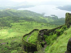
Yusuf Adil Shah created Bijapur with great architecture during the seventeenth century. The city was established in the 10th and 11th centuries by the Chalukas of Kalyani. Bijapur came under the Kiljis of the Delhi Sultanate, during the 13th century. Bahmani Sultanate of Gulbarga conquered the state in 1347. The city was called Vijapur or Bijapur.
The rule of Adil Shah dynasty ended in 1686 when Mughal Emperor Aurangzeb conquered Bijapur. In 1724 the Nizam of Hyderabad declared his independence in the Deccan. Bijapur came under his domain. Nizam suffered a defeat by the Marathas in 1760 and ceded the region to the Maratha Peshwa. British East India Company took over Bijapur in 1818 and clubbed it with the princely state of Satara.
Hampi is situated on the banks of Tungabhadra River and formed one of the cores of the capital of Vijayanagara empire. Hampi was spelt as Hampe earlier and was identified as Kishkinda, the monkey kingdom, in mythological referance.
Hampi is a village in northern Karnataka and is within the ruins of Vijayanagara, the former capital of the Vijayanagara empire. Hampi is also called "The City of Ruins".
Hospet is a small town in Bellary District, in North Karnataka. The town is in close proximity to the ruins of Vijaynagara Kingdom. Hampi, the site of the medieval empire, is situated 12 km from Hospet. It serves as a transport and accomodation center for the tourists visiting the ruins.
Hospet is developing as a major mining center as the surrounding areas are rich with iron ore mines. The Tungabhadra Dam harnesses the waters of the Tungabhadra River.
Mysore is well known for its palaces and the demon king Mahishasura. The Goddess Chamundeshwari destroyed the demon after ten days of heroic struggle. The nine day Navaratri festival celebrates this victory. The name Mysore is derived from Mahishuru which in turn comes from Mahisha.
Hubli-Dharwad is a twin city in the state of Karnataka. Hubli City, situated about 20 km east of Dharwad, is the commercial center of the district. Cotton and groundnuts are the major crops of this area.
Hubli is an important industrial center, with more than 1,000 small and medium sized industrial units. It is also an important railway wagon workshop. Hubli is the zonal headquarters of South Western Railway.
Belgaum city was built by Ratta dynasty in 12th century AD. Bichiraja, a Ratta officer, built the Belgaum fort in 1204 AD. The city served as the capital of Rattas during the early part of 13th century before this dynasty was replaced by Yadava Dynasty of Devagiri.
Belgaum, also known as the "Bamboo Village", is located in the north-western part of Karnataka. Its proximity to the coast and strategic position near Portuguese Goa, promoted the British to establish an army cantonment and a training center.
Bengalore is much more than just the fifth-largest metropolis in India. This vibrant city of 6 million people has become the 'Silicon Valley of India' and the name "Bangalore" is a code word for 'outsourcing'. The city is a power house of software exports from India to the rest of the world.
Kempe Gowda I, established the modern city of Bangalore in 1537. He built a mud fort in the city and established it as a province of the Vijayanagara Empire.
The city enjoys a mild climate which is very attractive to people from other parts of India.
This is the place where Rama, while searching for Sita, met Sugreeva and Hanuman. Goddess Durugamma is also called Balari and this city takes its name Bellary from that.
The district of Bellary came under the Sultanate of Bijapur in 1565. This territory was conquered by the Mughal emperor Aurangzeb in 1685. Bellary was placed under the authority of the Mughal governor of the Deccan called the Nizam. Once the Nizam broke away from the Mughals in 1724, he traded Bellary district with the British, in return for military protection.
Gulbarga was the capital of the Bahmani Kings from 1347 A.D. to 1428 A.D. The jami or Juma Masjid located inside the old fort was built by a moorish architect around the 15th century, in imitation of the great mosque in Cordova, Spain. Uniquely built, it has a huge dome canopying the entire area, four smaller domes and 75 smaller ones.
The come-back constituancy of Indira Gandhi, the former Prime Minister of India, Chikmagalur is well known for coffee production. The other commercial crops are pepper, cashew and areca nut. The district is rich in iron. Chikmagalur is surrounded by the Baba Budangiri hills and dense forest.
We had an opportunity to do a photo shoot, back in 1974, for the Coffee Board in Bangalore. Unfortunately no pictures or documentation has survived the last three decades.
Formerly known as Trivandrum, the "Ever Green City of India" is the capital of Kerala. Thiruvananthapuram has a population of 750,000 people and is the largest city in Kerala. The city is home to some prominent institutions like the Vikram Sarabhai Space Center.
Thiruvananthapuram is located on the west coast of India near the extreme south of the mainland. It is characterized by its undulating terrain of low coastal hills with wide clean roads and busy commercial alleys. It was the trading post for spices like the rest of ancient Kerala.
Kottayam, Kerala
Most of India's natural rubber originates from the plantations of Kottayam. This important commercial center is surrounded by some of the most beautiful scenery with Western Ghat Hills to the east and the famous Backwaters to the west. Kottayam is also the most mountainous region of the state.
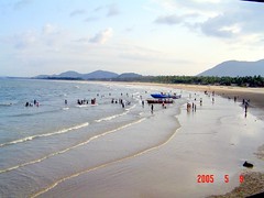
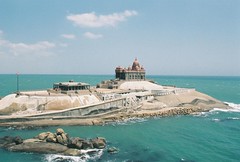
Kovalam beach is known as the "Paradise of the South". The beach is just 10 miles from Trivandrum, the capital of the state of Kerala. Kovalam is one of the best beaches in India, picturesque, evergreen, surrounded with coconut trees and very safe during the toughest weather.
The Ayurvedic massage of Kovalam is very popular. The Kovalam beach offers fresh seafood and good accomodation.
Formarly known as Calicut (Kalikut), Kozhikode is supposed to be the Arabic name of Kalikut. This is the place where Vasco da Gama landed in 1498. Kozhikode is the third largest city in the southern state of Kerala. The population of the city is estimated at 800,000 people.
In 1766, Hyder Ali of Mysore captured Kozhikode and much of northern Malabar Coast.
Vasco da Gama came to Kannur in 1498 and shortly thereafter it became a Portuguese settlement. They built the Saint Angelo's Fort north of Kannur in 1505. Dutch took over the area in the mid 17th century and then the British captured it in 1783.
The old name 'Cannanore' was the typical anglicised version of the Malayalam name Kannur. The district is a major center of Theyyam, a ritual dance of Northern Kerala.
Ernakulam is derived from the Tamil word Erayanarkulam which means 'Lord Shiva's abode'. The city is the commercial capital of Kerala, served by an international airport, fine communication facilities, excellent accommodation, modern amenities and a lot of attractive tourist places.
Ernakulam district was formed on 1st April 1958 by carving out areas out of Travancore-Kochi_Malabar kingdoms. Major portion of the district is from Kochi Kingdom. Ernakulam is the most urbanised part of Kochi.
Kollam is India's cashew trading and processing center. It is one of the oldest ports on the Malabar coast. The 8 hour boat ride between Kollam and Allappuzha is the longest and most enchanting experience on the backwaters of Kerala.
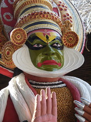
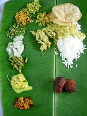
The food in Kerala is simple, clean and is served on banana tree leaves. The people of Kerala are highly educated and have a communist government for better part of it's independent history.
Kochi was the first princely state to join the Indian Union willingly. It is one of the principal seaports of the country. The city has a population of approximately one and a half million people. Kochi is located in the district of Ernakulam.
Thrissur Pooram festival is the most colorful and spectacular temple festival of Kerala. The city of Thrissur is located in the center of Kerala. It is the fourth largest city in Kerala with a population of half a million people. Thrissur may be called the golden capital of India. A hundred kilograms of gold is sold in the city, every day.
Thrissur gained importance during the reign of Raja Rama Varma in 1790. He ascended the throne of the State of Kochi. Thrissur became the capital of Kochi Kingdom for a brief period.
Raisen is a town in Madhya Pradesh State of Central India. It is the administrative headquarters of Raisen District. Raisen takes its name from a massive fort. This fort is built on a sandstone hill, at the foot of which settles the town. The name is probably a corruption of Rajavasini or Rajasayan, the royal residence.
Before India's independence in 1947, Raisen was part of the Princely State of Bhopal. After Indian independence it, along with most of the Bhopal princely States, became part of the new Bhopal State of India which was merged into Madhya Pradesh on November 1, 1956.
Sagar is located in the Malwa region at the north central part of Madhya Pradesh. The district is well connected by road and railway networks. The city lies around a lake framed by small hills. Bathing ghats (steps) lead into the lake and Hindu temples stand on its shores.
The city of Sagar was founded in the 17th century and a fort was built by the Marathas in 1780. In the early 1800s the British occupied the area and used the fort as a prison for roadside bandits, who were active in the region during that time.
Gwalior is an ancient seat of Jain worship. There are a series of cave and rock-cut sculptures numbering a hundred from the remains of the Jain period. Gwalior is also an example of palace architecture of the best of Hindu culture.
Datia, Madhya Pradesh
The town of Datia is situated near Gwalior. A princely state in Madhya Pradesh, Datia is only 25 km away from the town of Jhansi in Uttar Pradesh.
The old town is surrounded by a stone wall, enclosing beautiful palaces and gardens. The 17th century palace of Bir Singh Deo is one of the finest examples of Hindu architecture.
Raja Bhoj founded Bhopal between 1,000 and 1,055. The city was originally called Bhojpal. As part of the Vindya Range, Bhopal is a hilly area. It is the capital of Madhya Pradesh.
In 1984, methane gas leaked from the factory of Union Carbide that killed over 18,000 people and left thousands with permanent disabilities.
Malhar Rao Holkar ruled Indore and the Malwa region from 1724 till 1766. He was succeeded by his daughter-in-law Ahilyabai Holkar. She was the patron of arts and architecture and donated money for the construction of Hindu temples all across India. Holkars were defeated by the British in 1818. A treaty was signed at Mandsaur and the capital of Holkars was shifted from Maheshwar to Indore.
It is the largest city in Madhya Pradesh and is the commercial capital of the Malwa region. Indore has a population of more than 1.8 million people. Indore is also a major educational center of Madhya Pradesh with many engineering collages and management instititions.
The original name of the city was Shahjahanpur, named after the Mughal Emperor Shah Jahan, who came to the region in 1640. It was later called Shajapur for short. The town is located in the Malwa region of Madhya Pradesh.
In the 18th century, the town became part of the dominion of the Maratha leader Sindhia, founder of the State of Gwalior, and was the headquarters of a district of Gwalior State until Indian independence in 1947. After Independence, Shajapur and its district became part of Madhya Bharat state which was merged into Madhya Pradesh on November 1, 1956.
Located in the Malwa Region of Madhya Pradesh, Neemuch is known for major cash crop production of opium. It has one of the two important opium processing plants here.
Neemuch is also the birth place of Central Reserve Police Force (CRPF). The city has a large scale recruits training center for CRPF. It was an important British military cantonment, within the princely State of Gwalior, where the native troops of the Bengal army mutinied in 1857.
In the 13th century AD, the Baghels came to this area and ruled from Bandhavgarh until 1617, when Maharaja Vikramaditya Singh moved his capital to Rewa. Martand Singh was the last ruler of Rewa who acceded to the Union of India after the country became independent.
Situated along the Son River, Rewa is a small town in the State of Madhya Pradesh. The forests surrounding Rewa are renowned for their tiger population. The tiger sanctuary of Bandhavgarh is located here.
Narmadapur was the original name for the city of Hoshangabad because of the river Narmada. However, the name was later changed to Hoshangabad, a city in the Malwa region of Madhya Pradesh. It is located on the south bank of the Narmada River.
The city is famous for the beautiful Sethani Ghat along the banks of river Narmada. On the outskirts of the town, Government of India has a security paper mill, printing currency notes.
Named after the Lord Shiva, Shivpuri is located in the Gwalior Division of northwest Madhya Pradesh. The city was the summer capital of the Scindia rulers of Gwalior. Emperor Akbar captured herds of elephants from the dense forests of Shivpuri.
Tatya Tope was awarded death sentence on April 17, 1859 by British Raj for his part in the Revolt of 1857 in nearby Jhansi. He was hung to death in Shivpuri, at a site near the present collectorate.
Jabalpur is surrounded by marble rocks called Bhera-Ghat, along the Narmada River. The city is home to spiritual leaders like Maharishi Mahesh Yogi and Bhagwan Rajneesh. Jabalpur also held the 1939 Tripuri Congress session, presided by Subhash Chandra Bose.
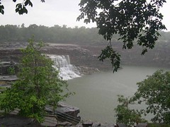
The famous waterfall, Bhedaghat is located 20 km from Jabalpur and is also known as Dhuandhar. Jabalpur has volcanic rock formations called the "Hanging Rocks of Jabalpur". The city is close to Kanha Kisli national park, the biggest tiger conservation program in India.
Balaghat is a city in south-central Madhya Pradesh, in central India. The city lies just east of Wainganga River and is a major manganese-mining center. Balaghat is also an important agricultural center with sugar milling as its main industry.
The traditional capital of Vikramaditya (Chandra Gupta II), Ujjaini as it was known, is located on the eastern bank of the Kshipra River in the Malwa region of Madhya Pradesh. The Kumbh Mela (religious festival) is held here every twelve years. It has been the first meridian of longitude for Hindu geographers since the 4th century BC.
Ujjain was invaded by the Delhi Sultanate led by Iltutmish in 1235. The city suffered widespread destruction and systematic desecration of temples. It became the capital of Malwa under the Mughal Emperor Akbar. During the 18th century, Ujjain became the headquarters of The Sindhias, the Maratha leader of the region.
Ratlam is a small city located in the Malwa region of Madhya Pradesh. It is a major railway junction on the western railway and is famous for its Diamond crossing.
Ratlam was a princely state during the British rule. The Raja of Ratlam was a Rathor Rajput who traced his ancestory to the ruling family of Jodhpur. For a brief period, it came under the rule of Scindias but then in 1861 the British government took over the administration.
Vidisha (Besnagar) a city in Madhya Pradesh state of central India, is situated east of Betwa River in the fork of the Betwa and Bes rivers. The Emperor Ashoka was the governor of Vidisha and it finds mention in Kalidasa's immortal Meghdoot.
The picture here does not represent Vidisha in any way except that this photograph was probably shot in this city. Since there was no other decent image available on Flickr, we decided to use what was possible.
Situated on the banks of Tapti River, Burhanpur is a small town in the state of Madhya Pradesh. This place is famous for its muslins, flowered silks and brocades. A large number of Boras, a class of muslim merchants, live here.
Naseeruddin Farooqi built the city in 1407 AD, in honor of his religious leader, Hazrat Shah Burhanuddin Gharib Khuladabadi. Farooqi dynasty ruled this city for over 200 years.
Panna was the capital of Chhatar Sal, the Bundela Rajput leader, who led a revolt against the Mughal Empire. Upon his death in 1732, his kingdom was divided amongst his sons, with one-third of the kingdom going to his ally, the Maratha Peshwa Baji Rao I.
The kingdom of Panna went to Harde Sah, the eldest son of Chhatar Sal. In the early 19th century, Panna became a princely State of British India and gained control of the States of Sohawal and Nagod. Raja Nirpat Singh assisted the British in the Revolt of 1857, and the British rewarded him with the title Maharaja. Maharaja Mahendra Yadvendra Singh acceded to the Government of India on January 1, 1950, and the kingdom became Panna District of the new Indian State of Vindhya Pradesh. Vindhya Pradesh was merged into Madhya Pradesh on November 1, 1950.
Pimpri-Chinchwad is a twin city of Pune, India. It hosts one of the biggest industrial areas in Asia. The city is home to the companies like Bajaj Auto, Telco, Kinetic, and Bajaj Tempo. The city is also home to India's premier antibiotics research institute Hindustan Antibiotics Limited. The main language of the area is Marathi.
The city was once the capital of King Bhoj, the well-known King who ruled central parts of India two thousand years ago. Bhosari is one of the most important villages of Pimpri Chinchwad. The real name of Bhosari is Bhojapuri which was the capital of king Bhoj.
Pimpri Chinchwad is well known for its Ganesh devotees.
The turmeric capital of India, Sangli and Miraj, the twin cities are located in the Indian State of Maharashtra. The city is part of the 'Sugar Belt' with 30 sugar factories, which makes it amongst the highest sugar-producing districts of India. Sangli is also known for high quality of grapes.
Sangli city known as Natyapandhari, the birthplace of Marathi drama. It has a historic Ganpati temple built in 18th century by ruling Patwardhan dynasty of Sangli, appointed by Peshwas of Pune. The temple attracts thousands of devotees year around.
Pune (formerly Poona) is the 8th largest city in India with a population of 4.5 million people. It is the 2nd largest city in the State of Maharashtra. Pune is home to some very reputed educational institutions and many software and IT companies. The city is considered the cultural capital of Maharashtrians. Pune is fast developing into a very cosmopolitian city.
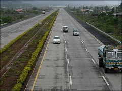
Mumbai Pune expressway is a six lane highway connecting two major metropolis. Once the entry to the highway is cleaned up on both sides, this could usher in a new age of development to the region.
Pune is inextricably linked to the life of the great Maratha hero and King, Chhatrapati Shivaji. The era of Pune's fame began when Chhatrapati Shivaji came to stay here with his mother Jijabai in 1635-36. They lived in a mansion known as "Lal Mahal," a replica of which still can be visited at its original location in the city. According to local lore, the Kasba Ganapati Mandir, regarded as the presiding deity of the city (gramadevata), was built by Jijabai.
Nanded, Maharashtra
Nanded is a Sikh holy city, located on the banks of River Godavari in Maharashtra, India. It is the resting place of Shri Guru Gobind Singh, tenth guru of Sikhism who played a monumental part in the development of the Sikh faith. Nanded is one of the historical places in Marathwada Region in Maharashtra State.
Virar, the last station on the Western Suburban local train route of Mumbai, was connected with the mainland by an electric train way back in 1925. Seventy percent of the population of Virar is below 30 years of age because of migration from mainland Mumbai.
Arnala is an excellent beach in Virar. Jivdani temple, situated atop a hill with some 1375 steps, offers a very picturesque view of Virar.
Located in the Western Ghats on the banks of Godavari River, Nashik or Nasik is a city of 1.2 million people in the State of Maharashtra. Historically, the city has been a religious center - it is one of the four cities in India that hosts the massive Sinhastha Kumbh Mela once in twelve years. Temples and ghats (steps) on the banks of Godavari River have made Nashik one of the holiest places for Hindus all over the world.
The third most industrialised city of Maharashtra, after Mumbai & Pune, is famous for its grapes, and ongoing efforts are underway to promote the growth of an export-oriented wine industry in the district.
Mumbai is the state capital of Maharashtra as well as the financial capital of India. No one picture can capture the soul of Mumbai. Yet this one atleast makes you think of so many evenings spent on Juhu Beach.
Dhule city in northwestern Maharashtra has a population of approximately 225,000 people. The city was designed by Sir Vishveshwarraya along the banks of Panzara river. Dhule city is famous for its quality of educational institutions. It is also an important center for cotton-textile manufacturing.
Dhule came under the Mughal rule in 1601, during the reign of Akbar. Marathas took over the rule over Dhule in the 18th century. In 1818, the British annexed the city and consolidated it under the Bombay Presidency.
Navi Mumbai, Maharashtra
Navi Mumbai (New Bombay) is the largest planned new city in the world. Covering an area of 344 km, the city lies on the mainland on the eastern seaboard of the Thane Creek. The length of the city is almost the same as Mumbai. Navi Mumbai was created in 1970s to cater to the rising demand in real estate.
CIDCO (City and Industrial Development Corporation) was formed on 17th March 1971 and was given the mandate of converting about 344 km of marshy land lying between village Dighe in Thane district and Kalundre village of Raigad district into a new city. It consisted of 150 km creek line of the total 720 km of the Konkan coast.
Satara is a town located in the State of Maharashtra and is home to the first Sainik School of India.
The city of Satara was the seat of the former Maratha Maharajas, the nominal rulers of the Maratha empire until its conquest by Britain in 1818. The Maratha empire was founded by Shivaji in the 17th century. His descendants had lost effective control of the Maratha State by the mid-18th century, which had passed to the Peshwas, who moved the capital to Pune in 1749. After their victory in the Third Anglo-Maratha War in 1818, the British annexed most of the Maratha territory to Bombay Presidency, but restored the titular Raja Pratap Singh, and assigned to him the principality of Satara, with an area much larger than the present district. As a result of political intrigues, he was deposed in 1839, and his brother Shahji Raja was placed on the throne. This prince died without male heirs in 1848, and Satara was annexed by the British government and added to Bombay Presidency.
A city of 1.5 million people could be considered a suburb of Mumbai. It is the first fully literate city in Maharashtra and the second in India. Old Dombivli which forms the west flank is embraced by the river Ulhas.
Today, Dombivli is well known for its rapid industrial growth with major companies like Lloyd Steel, Deepak Fertilizers, Vicco Labs and Gharda Chemicals.
Famous for its Kolhapuri Chappals (leather footware), Kolhapur has lot more to offer. It is part of a major sugar belt and therefore has a poweful sugar lobby in the state politics. Kolhapur has a national stadium for wrestling known as Khasbag. The city is also popular for its Mahalaksmi temple, situated on the banks of Panchganga river.
Kolhapur was a princely state under British India with Bhonsle dynasty as its rulers. The states of Satara and Kolhapur were created in 1707.
Located on the 'Mumbai Bhusawal Nagpur' route of the Central Railway, Shegaon is a town in the Buldhana district of the State of Maharashtra.
Shri Sant Gajanan Maharaj took "Samadhi" at Shegaon and a temple is built on the Samadhi. It is the biggest temple trust in Vidharbha region. Hindus consider Gajanan Maharaj a saint with miraculous powers.
Aurangabad is located in the Marathwada region of Maharashtra and is the closest city to the famous Ajanta and Ellora caves. The city is named after the Mughal Emperor Aurangzeb. In 1610, Malik Amber, the Prime Minister of Murtaza Nizam Shah II of Ahmednagar, founded the city at Kirki (Khadki) called Fatehpura. Aurangzeb was sent to the city in 1634 as Governor of Deccan. He moved back to Agra in 1644.
Aurangzeb returned to the city in 1681 as Emperor and used this location as a base for his campaigns to conquer the last remaining sultanates in the Deccan. He lived in Aurangabad till his death in 1707. His tomb is situated at Khultabad, a small town near Aurangabad. The city took its name after his death.
Located on the east side of Marathwada Region, Osmanabad lies on the Deccan plateau in the State of Maharashtra. Parts of the Godavari and Bhima Rivers flow through the district.
Osmanabad District has a population of 1.5 million people.
The city was founded in 1866 on Wardha River in the state of Maharashtra. Wardha is part of the cotton belt in the state politics. It is a sister city of Sevagram, and both were used as major centers for the Indian Independence Movement. Wardha was the headquarters for the annual meet of the Indian National Congress in 1934.
This city of 125,000 people was once a part of the legendary kingdom of Vidarbha, mentioned in Mahabharata. Yavatmal, along with Berar province, was also a part of the Mauryan Empire. The Nizam of Hyderabad seized control of the southern provinces in 1724, including Berar. In 1853, the whole area came under the administration of the British East India Company.
Yavatmal is also known as cotton city. The town is also the chief trading centre for cotton-ginning and pressing. Cotton and teakwood are the main exports of the district.
The first railway train in India ran from Bombay VT (Victoria Terminus) to Thane in 1853. Thane or Thana means "station" in local language. Thana was the only other station besides Victoria Terminus.
The Portuguese ruled over Thane for 200 years, from 1530 to 1739. The city was then known as Cacabe de Tana. Work on the Thane Fort began in 1730. The Marathas conquered Bassein and Thane in 1739 and held on to the region till 1784 when the British captured the Fort and ruled Tana (Thane).
The city of Thane is situated on the western banks of Thane creek with Parsik hills to the east and Yeour hills to the west. The creek not only provided a natural protection to the city but also facilitated transport of big and small ships since ancient times.
The city is located on the north bank of Vasai Creek and Ulhas River. Vasai-Virar is part of Thane District in Maharashtra and has three railway stations on the Western Railways. The 3 suburban stations are, Vasai Road, Nala Sopara and Virar.
The ancient city of Sopara and the town of Vasai were important trading centers for horses, fish, salt, timber, and quarried basalt and granite. Vasai came under the control of the Sultans of Gujarat in the 15th century. The Portuguese captured it in 1532.
Nagpur is the winter capital of the State of Maharashtra. Located in the eastern Vidarbha Region, Nagpur has a population of 2.1 million people. It is the third largest city in the western State of Maharashtra after Mumbai and Pune. Nagpur is considered the 'Orange City' because of huge trade of high-quality oranges grown in the region.
TATA, one of the most respected industrial houses in India, started the country's first textile mill at Nagpur, formally known as Central India Spinning and Weaving Company Ltd. The company was popularly known as "Empress Mills" as it was inaugurated on 1st January 1877, the day queen Victoria was proclaimed Empress of India.
The second Anglo-Maratha war took place in Akola District of Maharashtra in November, 1803. The British were led by Governor Arthur Wellesley and the Marathas under Bhonsle of Nagpur.
Gadchiroli has a population of over a million people. The district is considered a tribal and undeveloped district and most of the land is covered with forest and hills. Gadchiroli is well known for Naxalite activities.
This summer capital of the British Raj was established in 1829 as Malcolm Peth, today it is known as Mahabaleshwar. It is also one of the few Evergreen Forests of the world.
Located near Pune and Mumbai (Bombay), Mahabaleshwar is a vast plateau with tremendous potential to develop as a major hill resort.
The birth place of Bal Gangadhar Tilak, Ratnagiri is located in the south-western part of Maharashtra. The city is a part of the long coastline of Konkan tract, along the Arabian Sea coast. The surrounding area is bordered by the Sahyadri Hills on the West. The fertile alluvial soil is good for the production of rice, coconut and cashew cultivation. Ratnagiri is famous for its golden Haapus (Alphonso) mangoes.
The Ratnagiri fort was built by the Bijapur dynasty and was strengthened by Maratha King Shivaji in 1670. This is the fort where Veer Savarkar was confined during the freedom struggle.
Popularly known as the Sindhi City, Ulhasnagar is home to some half a million people. After the partition of India, over 100,000 Sindhi refugees from the newly created West Pakistan were relocated in military camps five kilometers from Kalyan. The area was converted into a townshop in 1949 and named Ulhasnagar..
In 1955, a suburban railway station was built and that transformed Ulhasnagar into a major business district. It is home to some 350,000 Sindhis, the largest enclave of this ethnic group in India.
The birth place of the famous painter M. F. Hussain, Pandharpur is a town in the State of Maharashtra. Located on the banks of Bhima River, Pandharpur is one of the most respected pilgrimage sites in Maharashtra. It hosts the Vithoba temple, on the banks of the river. Vithoba is supposed to be Krishna, an incarnation of Vishnu.
This temple, covering a vast area, has a total of six gates. The eastern entrance to this temple is known as the Namdev gate. The sanctum enshrines a standing image of Vithoba also known as Panduranga, Pandhari or Vitthala.
Solapur, Maharashtra
Solapur is one of the biggest cities in Maharashtra, situated near the borders with Karnataka and Andhra Pradesh. It is an ancient historical and religious place with Shri Siddharameshwar as its "Gramadaiwata". Shri Siddharameshwar was a historical figure of the 12th Century whose "Karmayoga" on his own native land-Solapur, turned him into a God-figure over the course of time. He composed more than 65,000 Vachanas and consecrated 68 "Lingas" in Solapur. He belonged to the Virashaiva movement inspired by the saint and revolutionary Basavanna. He had gained the "Siddhi". As Solapur was a drought prone area, Shri Siddharameshwar dug a lake with the help of 4000 "Sharanas" to solve the problem of portable water, which was open to use for people of all castes, races and religion. He entombed himself alive (Shivyogsamadhi) at Solapur.
During the Indian independence movement, the people of Solapur enjoyed full freedom on 9th, 10th and 11th May1930.However, this resulted in the executions of Shri Mallappa Dhanshetti, Shri Kurban Hussein, Shri Jagannath Shinde and Shri Kisan Sarda who were hanged on 12th Jan1931, in the prison at Pune. This resulted in the city becoming recognized as "The City of Hutatmas".
Solapur is 433 km away from Mumbai and 244 km from Pune. By rail, it is 456 km from Mumbai. Solapur is well-connected with metro-cities like Delhi, Hyderabad, and Bangalore.
Being an important industrial city, Solapur is a leading center for cotton mills and power looms. Solapur bed-sheets, terry-towels and chaddars have earned international fame and reputation due to their novel designs and durability.
The city is famous for its gold market, reputed to be pure. Jalgoan is a significant agricultural region of Kandesh. The district is well known for banana production. Formerly, a territory of the Holkar family, Jalgaon became part of British India's Bombay Presidency in 1818.
The region's rich volcanic soil is particularly well-suited for cotton production. Jalgaon is an important center for cotton-textile and vegetable-oil mills.
Chiplun is a city of 60,000 people, located in the konkan region of Maharashtra. The city lies on the banks of river Vashishti. The reign is hilly and the city is situated in the valley, and is surrounded on all four sides by hills.
Chiplun is an industrial town catering to mostly the top pharmaceutical and chemical industries. It also has Rajaram Shinde College of Engineering affiliated to the University of Mumbai.
The capital of Manipur, Imphal has a unique bazaar where all the shops are managed by women. The place is called 'Ima Keithel' at Khwairamband Bazaar. Imphal is full of small rivers draining from the surrounding hills.
In 1944, during World War II, the Battle of Imphal, along with simultaneous Battle of Kohima, was the turning point in Burma Campaign. For the first time in the South-East Asian Theatre of World War II the Japanese lost the initiative to the Allies which they then retained until the end of the war.
In the heart of the town and surrounded by a moat, are the ruins of the old Palace of Kangla.
Shillong is the capital of Meghalaya and has a population of 250,000 people. The city was also the capital of undivided Assam until the creation of the new State of Meghalaya in January 1972.
The city boasts of many beautiful churches and cathedrals. The colonial hangover of Shillong is not yet over. People still do not feel emabarrassed to describe their city in terms of Scotland of the east or Glen Eagle of the east. Picinic spots in and around Shillong include Elephant falls in upper Shillong, Spread Eagle falls, Ward Lake, Bara Pani.
Aizawl is the capital of Mizoram, an eastern state of India, and is situated on top of a hill. The city is surrounded by slopes and valleys and has breathtaking views. The city has a population of 250,000 people and it offers plenty of tourist attractions.
During World War II, the battle of Kohima was the turning point for the Allied forces. The engagement at Kohima and Imphal, was the first sign of Japanese loosing their initiative in their Burma campaign.
Kohima is the capital of Nagaland, one of the seven sister states of Eastern India. Nagaland shares its borders with Burma.
Once the capital of ancient Kalinga Kingdom, Bhubaneswar is called The Temple City of India. Located on the east coast of India, the city has a population of over a million people. Bhubaneswar became the capital of the state of Orissa in 1948.
The famed Lingaraj Temple of old Bhubaneswar was built in the 11th century and forms an integral link in the Golden Triangle. The other two points are The Sun Temple of Konark and Jajannath Temple of Puri.
Located on the coast of Bay of Bengal, Puri is one of the oldest cities in the eastern part of India. The eleventh century Jajannath temple is the main attraction of the city in the State of Orissa.
Puri is also famous for its annual Ratha Yatra, or "Festival of Chariots", when the deities Jagannath, Baladeva, and Subhadra are brought out of the temple, and placed in a chariot procession. This festival occurs on various dates of the Gregorian calendar, typically in the month of July.
Konark is a small temple town in the state of Orissa. The sun temple was built by King Narasimhadeva in the 13th century. Konark temple is one of the most important Brahman sanctuaries and is built in the form of a huge chariot. The huge Surya (sun god) chariot is drawn by seven horses on 12 pairs of very decorative wheels. The entrance is guarded by two lions.
Konark has a popular beach but the main attraction is the sun temple. The temple is now partly in ruins and so part of the collection of sculptures is housed in the Sun Temple Museum.
The warlike Keshari Dynasty founded a Kataka or "military camp" here in AD 989. In the 11th century, the Kesharis were again responsible for building the impressive granite embankment on the south bank of the island. Barabati Fort was added on the north bank in the 14th century. Two hundred years later, Orissa's last independent Hindu ruler, Mukunda Harichandan, built a much grander, nine-story palace on the same site. The Raja never had much of a chance to enjoy it however, as only eight years after his succession the Mughals and soon after, the Afghans of Bengal, annexed the city.
Cuttack is located in the eastern Indian state of Orissa around 30 km off Bhubaneswar. The former capital of Orissa and the oldest city in the region, Cuttack today is a bustling commercial center.
The city was established in 1481 by Lodhi Dynasty. Meer Hota was the name of this place which was changed to Lodina by the Lodhis. It was finally changed to Ludhiana, now a sprawling city and a fast growing industrial center.
Ludhiana is the most populous city in Punjab with a majority of the people of Sikh faith. The population of Ludhiana is over 2 million people. This city is also called the "Manchester of India" because of a very large hosiery sector.
The land of Golden Temple and dominated by the history of the Sikhs. It is also known for the Amritsar massacre by the British. Amritsar became the most important city during the time of Maharaja Ranjit Singh.
Firozpur, Punjab
The city was founded by Firoz Shah Tughluq (1351-1388), sultan of Delhi. Firozpur has a population of about 80,000 people and is located near the Sutlej River and the Pakistani border.
Beas, Punjab
Beas is the headquarter of the Radha Soami spiritual movement. Millions of people travel to this city every year to attend the Satsang (discourses) at the Dera Baba.
Beas is located along the banks of Beas River, in the district of Amritsar, Punjab. It is situated between the cities of Amritsar and Jalandhar. Beas is only 20 km from Kapurthala.
Faridkot was named after the Sufi Saint Baba Sheik Farid Shakargang, whose verses are mentioned in Guru Granth Sahib, the holy book of Sikh religion. Earlier, the city was called Mokalpur.
Fatehgarh Sahib district is one of the nineteen districts in the state of Punjab in North-West India. Its major city is Mandi Gobindgarh - the steel town of India.
Jalandhar is known as the sports city of India. It is probably the biggest sports goods manufacturer in the country. Jalandhur is the industrial capital of the state of Punjab. Twelve of India's greatest hockey players have come from a single village, Sansarpur, in Jalandhar district.
The Gurudwara at Kartarpur (16 km from Jalandhar city) was built by the fifth sikh guru, Arjun Dev in 1656.
Formerly the capital of the premier princely State of British India, Patiala is an important cultural city of the State of Punjab. Because of the active patronage of the erstwhile rulers of Patiala, a well established style of Hindustani music called the "Patiala Gharana" came into existence and has continued to hold its own till today. The most well known exponent is Ustad Bade Ghulam Ali Khan who achieved world wide fame and brought glory to the Patiala Gharana.
Baba Ala Singh carved out an independent principality from a petty Zamindari of 30 villages. Under his successors, it expanded into a large state. In the middle of the eighteenth century, Baba Ala Singh, unlike many of his contemporaries, displayed tremendous shrewdness in dealing with the Mughals, Afghans and Marathas and successfully established a state which he had started building up from its nucleus Barnala.
In 1763 Baba Ala Singh laid the foundation of the Patiala Fort known as Qila Mubarak, around which the present city of Patiala developed. After the Third Battle of Panipat in 1761 in which the Marathas were defeated, the writ of the Afghans prevailed throughout Punjab. It is at this stage that the rulers of Patiala began to acquire ensigns of royalty. Ahmad Shah Abdali bestowed upon Ala Singh furm and banner, and the title of Maharaja of Patiala.
Ajmer was founded by Raja Ajay Pal Chauhan. The city is best known for the Dargah (tomb) of the famous Sufi Saint, Moinuddin Chisti. The city has a population of over half a million people.
Sariska National Park, Sariska, Alwar District, Rajasthan, India
SariskaNational Park is located 35 kms from AlwarCity, along the lap of Aravalli Hills in the Alwar District of Rajasthan. Originally, it was the hunting reserve for the erstwhile State of Alwar. Sariska was declared a wildlife sanctuary in 1955 and became a tiger reserve under ‘Project Tiger’ in 1979. The Sariska Tiger Reserve was converted to a National Park in 1982 and now stretches over 866 sq kms with a core area of 497 sq km. The Park is located 107 km from Jaipur, the capital of Rajasthan.
The SariskaNational Park includes some important archeological sites like the NeelkanthMahadevTemple, GarhRajorTemples and the Kankwadi Fort. In the medieval times, Aurangzeb, the Mughal Emperor imprisoned his brother Dara Shikoh in the Kankwadi Fort after the war for the throne ended between the Mughal brothers. Dara was defeated on June 8, 1658 AD by Aurangzeb at the battlefield of Samogarh, 13 kms from Agra.
The princely State of Alwar was founded by Pratap Singh Prabhakar Bahadur (1740-1791 AD), a Rajput of the Kachhawaha lineage in 1775 AD. His adopted son, Bakhtawar Singh (1791-1815 AD) signed a treaty with the British East India Company in 1803 AD. Like his father Pratap Singh, Bakhtawar Singh further consolidated the State of Alwar but his local administration was inefficient. The state borrowed a lot of money from outside as the finances were mismanaged.
The State of Alwar was heavily indebted when the next ruler Maha Rao Vinay Singh (1815-1857 AD) ascended the throne. The new ruler was firm and effective and successful in stabilizing the general administration. He took complete control of the law and order situation and established criminal courts. Vinay Singh started the collection of land revenues in cash instead of kind. He introduced the Muslim ministers in his administration from Delhi in 1838 AD.
Sheodan Singh (1857-1874 AD) was only 12 years old when Maha Rao Vinay Singh died in 1857 AD. His rule began under the influence of the Dewans of Delhi. The local Rajput nobles rebelled and slaughtered the representatives of the Dewans of Delhi and sacked the Muslim ministers. The British intervened and sent Captain Impey as a Political Agent to Alwar in 1858 AD.
Maha Rao Sheodan Singh assumed the formal rule in September 1863 AD, and the British agency was abolished. Once again the Dewans from Delhi entrenched themselves in the administration and provoked another uprising of the Rajputs. The British once again took control in 1867 AD. Mangal Singh (1874-1892 AD) was also a minor when he succeeded Sheodan Singh as the next ruler of the State of Alwar. The British Political Agent continued to rule on behalf of Mangal Singh till he assumed the title of Maha Rao in 1889 AD. Mangal Singh himself supervised the military forces.
Maha Rao Mangal Singh died in 1892 AD and was succeeded by his only son, Jai Singh (1892-1937 AD). Maha Rao Jai Singh was also a minor when he inherited the throne of Alwar. He was assisted by the British and a State Council. Jai Singh was a good administrator and he established twelve administrative units called Tahsils to be governed by a Tahsildar. His long rule of 45 years was followed by Tej Singh (1937-1971 AD).
Baran town is carved out of Kota city and is situated further into the Hadoti Region of Rajasthan. The Region is less crowded and attracts tourists who like to wander through isolated areas and in the interiors one can chance upon a ruined temple here and an abandoned fortress there. There are wooded hills and valleys that provide shelter to a large variety of wildlife of Rajasthan.
Baran is a District of the State of Rajasthan in Western India. The town of Baran is the district headquarters.
The district has a population of a million people. It is bounded on the north and east by Madhya Pradesh State, on the south and southwest by Jhalawar District of Rajasthan, and on the west and northwest by Kota District of Rajasthan.
Before Indian independence in 1947, most of present-day Baran District was part of the princely State of Kota, although Shahabad Tehsil was a discontinuous portion of Jhalawar princely State, and Chhabra Tehsil was a discontinuous portion of Tonk princely State. After Indian independence, the rulers of the princely States acceded to the Government of India, and the present-day Baran District was made part of Kota District. Baran District was carved out of Kota District on April 10, 1991.
The city of Barmer was founded by Bar Rao (Bahada Rao) in the 13th century, when it was named Bahadmer. Barmer district is located near the border with Pakistan, in Thar desert. Every year a cattle fair is held at Tilwara village situated on the banks of Luni River in Barmer district. The fair is held in March-April and goes on for a couple of weeks. This is the best time to visit Barmer.
Barmer is famous for its handicraft, carved wooden furniture and hand block printing industry.
Who has not heard of Bharatpur Bird Sanctuary in eastern Rajasthan? Keoladeo National Park is one of the finest bird sanctuary in the world. Every year the rare Siberian cranes come to spend the winter in the warmer climate of Bharatpur. It is a painter's dream come true.
Bharatpur was the premier Jat State in Rajasthan. Badan Singh built the fort and palaces of Deej in 1725. Seven years later, his son laid the foundation of the fort of Bharatpur. It was a formidable structure called Lohagarh Fort (Iron Fort) which lived up to its reputation.
Roa Bikaji founded the city in 1486 in the midst of the desert in north-western Rajasthan. Bikaner was part of the larger Region called Jangladesh. The area was mainly inhabited by Jaats and their main transport being the camels.
Bundi, Rajasthan, India
The City of Bundi (Hadoti Region) was established around 1241 AD by the Hada Rajput Chief Rao Deva, or Deoraj, who captured the town from the Bhils and other tribals of the area. In the past, a tribe called Meena (notorious robbers) inhabited this region and Bundi derived its name from the tribe' chieftain's name - Bunda Meena. The State lies on the north-east of the River Chambal, in a wild and hilly tract, historically known as Hadoti.
The City of Kota was established as early as 1264 AD but was part of the Hadoti Region ruled by the ruler of Bundi. In 1579 AD, the ruler of Bundi, Rao Ratan Singh handed over the smaller principality of Kota to his son, Madho Singh. This arrangement continued till 1624 AD when Emperor Jahangir, the great Mughal ruler, partitioned Bundi and made Kota an independent State. Rao Madho Singh ascended the throne of Kota.
The State of Bundi, older and more picturesque than Kota, never recovered from this partition of Hadoti Region. Bundi suffers from an inferiority complex as Kota has developed into a major industrial area while Bundi still lives with its past glory. The mighty River Chambal divides the two Hada Kingdoms created by the descendents of the Rajput Chauhans of Ajmer.
This outstanding Palace, built during the 16th and 17th centuries, is on the side of the hill below the Fort. It is a classic Rajasthani architecture. Only part of the Palace is open to the public. The Palace is entered through the Hathi Pole (Elephant Gate) into a small courtyard. Hathi Pole was built by Raja Ratan Singh in 1620 AD. You then come to the Ratan Daulat, the Diwan-e-am(Hall of Public Audience), where there is a marble throne.
Adjacent to the fort and past the bazaar, a wooden gate leads to the beautiful BundiPalace. The highlight of this palace is the beautiful murals that carry the spectators back into the time of Bundi royalty. The murals cover almost entire palace walls; however, all these areas are not open for public viewing barring the Chitrashala. For visiting other areas, special permission needs to be obtained from the secretary of the Maharaja of Bundi. Photography is not allowed otherwise Bundi palace, illuminated with lights during night, presents a glowing beauty to be captured on camera.
Bundi is known as the “City of Stepwells”. It has about fifty beautiful tanks and stepwells called “Baoris”. This one known as “Rani Ji Ki Baori” or “Queen’s Stepwell” is the best because of its architectural beauty. It was built in 1699 AD by Rani Nathawat Ji, the Queen of Rao Raja Anirudh Singh of Bundi (reigned from 1681 to 1695 AD) who distinguished himself in the Imperial Campaigns of Aurangzeb in the Deccan, in the seize of Bijapur and also saw service in Afghanistan. Baoris used to be the center of religious and social functions in those days. Rani Nathawat Ji is reputed to have built twenty such Baoris. This Baori was constructed during the reign of her son, Maharao Raja Budh Singh, who ruled Bundi from 1695 to 1729 AD.
Chittor was part of the Mewar Kingdom ruled by the legendary Bappa Rawal of Sisodia Dynasty. In 1303, the Sultan of Delhi, Allauddin Khilji was smitten by the beauty of Rani Padmini and took her husband hostage to force her to come to him. The whole incident of eventual battle and subsequent Johar is one of the most recounted stories of the Indian history.
Churu is a town in the desert Region of Rajasthan. It is famous for shifting sand dunes of Thar Desert and beautiful grand Havelis with marvelous fresco paintings namely Kanhaiya Lal Bagla ki Haveli, and Surana Haveli with hundreds of small windows is equally famous. It also has some fine Chhatries.
The Churu city was founded in 1620 by a Jaat chieftain called Churu. It was part of Jangladesh prior to annexation by Rathores. Churu was ruled by Thakur Maldeo, grandson of the famous Rao Kandhal and uncle of Rao Bika-Rathore Rajputs of Bikaner. In 1871 AD Churu fell to Bikaner. In this battle between the forces of Churu and Bikaner when all the copper & brass exhausted Churu, Thakur asked his womenfolk to part off their silver ornaments and with this metal, shells for the canons were made and used in the battle. The famous temple of Salasar Balaji is situated in this District.
Dausa, Rajasthan, India
The Kachwaha Rajputs of Central India first moved into Rajasthan through Dausa, which was then ruled partly by the Chauhans and partly by the Birgoojur Rajputs. Dulhe Rai (also known as Tej Karan) the Kachwaha descendent of Gwalior, married the daughter of Ralhan, the Chauhan ruler of Ajmer. He received Dausa as dowry, which was part of the Dhundhar region of Rajasthan. The Meenas Kings were the early rulers of Dhundhar. In 1037 AD, Dulhe Rai annexed the land from the tribe of Meenas and made Dausa his capital. He further initiated the conquest of Khoh and other areas of the Birgoojur Rajputs. Dhundhar region includes the present districts of Jaipur, Dausa, Sawai Madhopur, Tonk and northern part of Karauli.
Such is the pedigree of a city called Dausa that one would expect this historic city to look something like Jaipur or Amber. After all, the Kachwahas ultimately moved their capital to Amber and then finally to Jaipur. What you see today is a sleepy little city where nobody has heard of Mataji ka Mandir, Pratap Vatika or even the BalajiMahadevTemple.
The District of Dausa is basically known for the Chand Baori (step well) at Abhineri. The Baori has come into focus after the release of a popular film “Paheli”. The megastars like Shah Rukh Khan and Rani Mukherjee have created such awareness of this spectacular monument. Legend has it that the Baori was built by ghosts in one night. The sculptures surrounding the Baori are artistic and a marvel of excellence for their craftsmanship. This could be an enormous draw for the tourism business for the District of Dausa.
The city of Dausa has a ShivTemple called NeelKanthMahadevTemple on top of a hill where a large stone Linga was found with only its top visible above the ground. The temple is located on the Aravalli mountain range and has quite a steep climb to the top. Unfortunately, before you approach the temple complex, you have to go through a sizable community of houses with small, narrow lanes leading up to the base of the temple and the 200 year old monument is totally unprotected. It is likely that you would come across some riff-raffs, even before you decide to make the climb. Mr. Sachin Pilot, the Lok Sabha member from Dausa can look into this predicament and make a contribution.
The other monument of consequence in the city of Dausa is the Dargah of Hazrat Khwaja Jamaluddin Shah Baba. Few in the city have heard about this Dargah and when you reach the shrine, the people in and around are very helpful and courteous. Unfortunately, the Khadims at the Dargah have no clue about the story of Hazrat Khwaja Jamaluddin Shah Baba. They all were either born or brought up within the Dargah complex. The Dargah itself is a modest monument, located in peaceful surroundings. Despite the unfortunate lack of knowledge, it is generally believed that nobody ever returns from there without getting one’s wishes fulfilled.
The present town of Dholpur, which dates from the 16th century, stands somewhat to the north of the site of the older town built in the 11th century by Raja Dholan (or Dhawal) Deo, a Tomara Rajput chieftain; it is named Dholdera or Dhawalpuri after him.
Dholpur is well known for its excellent sandstone.This red stone was used to build not just the local structures but also those of Delhi like the Red Fort. In fact, the architect of modern Delhi, Edward Lutyens, had a special liking for it.
Established by Rawal Veer Singh in 1282, Dungarpur (the City of Hills) was one of the major cities of the Vagad Region. Veer Singh acquired this land from the Bhil chief Dungaria from whom the place got its name. Dungarpur district is the stronghold of the Bhils, a tribe whose history of occupancy in the Aravalli Range is said to date back to 4000 BC.
Dungarpur is a city in southern Rajasthan. The Mahi River runs along the western edge of the District, forming the boundary with Banswara District. The Som River, a tributary of the Mahi, runs along the northern edge of the District, largely forming the boundary with Udaipur District. The District is bounded on the east by the State of Gujarat.
Ganganagar, also called Sri Ganganagar, is a city in Rajasthan State of western India. It is named after the Maharaja of Bikaner 'Maharaja Ganga Singh' who established it. It is said that the Maharaja wanted a city based on the design of Paris to be established and hence the map of the Old Ganganagar city will give you a glimpse of the map of Paris. It is a testimony to land tranformation: Desert land was converted to a lush green town credited to the efforts of the Maharaja who bought the Rajasthan canal which carries the excess waters of Punjab and Himachal Pradesh to the Region, making Ganganagar known as "the food basket of Rajasthan".
'Hanumangarh' is a town in northern Rajasthan State in western India, located 300 km from Delhi. It is the administrative seat of Hanumangarh District. Hanumangarh was the Kingdom of 'Bhati' Rajputs and hence its earlier name was 'Bhatner'. Later it was named 'Shardulgarh' when Raja Shardul Singh won it. Since it was won on a tuesday, which is the ominous day for monkey-god Hanuman, it was rechristened as 'Hanumangarh' - the Fort of Hanuman Monkey-God. A 900 year old 'Bhatner' fort is situated in the middle of 'Hanumangarh Town', the description of which can be found in 'Aaine-Akbari'. A famous 'Bhadrakali temple' is situated near the town on the banks of Ghaggar river.
The princely state of Jaipur was established by Dhula Rai in 1128. The city of Jaipur was founded in 1728 by Maharaja Sawai Jai Singh, the famous mathematician and astronomer. The ruling dynasty of Jaipur gave the Mughal Empire, some of their most distinguished generals. The most famous amongst them were Raja Man Singh I and Jai Singh I.
The city was built of pink stucco in imitation of sandstone and therefore it is popularly known as the Pink City. The population of Jaipur is more than 2.7 million people.
Jaisalmer Fort - Jaisalmer, Rajasthan
The honey-hued city of Jaisalmer was established in 1156 AD by the Bhatti Rajput chieftain, Rawal Jaisal. The Bhatti Rajputs are descendents of the Yaduvanshi (Yadavs) clan. Yadavs believe that they are the direct descendents of Lord Krishna, the legendary “Avtar” of the Mahabharat fame.
The Bhatti Rajputs were driven out of their homeland in Punjab by the Turk invaders. Legend has it that the king of Ghazni (Afghanistan), Shal Bahan was sacked by Mamnenez, the king of Khorasan. Shal Bahan established his new capital at Sialkot in United Punjab. One of his sons was Rao Bhati and his descendants came to be known as Bhattis.
Once the clan of Bhattis was sacked in Punjab, they moved southwards and found a refuge in the Indian desert of Rajasthan. This could be around the 8th century and Lodurva, located 16 km to the south-east of present Jaisalmer, became their capital. Deoraj a prominent prince of the Bhatti family became the real founder of the Jaisalmer dynasty and they adopted the title of Rawal.
Jalore, Rajasthan, India
Jalore was ruled by the Paramara Rajputs till the Nadol Rajputs captured the Jalore Fort in 1181 AD. In medieval times, Jalore was known as Jabalipura. The town of Jalore was known as Suvarnagiri or the Golden Mount, on which the Fort stands. It was a flourishing town during the Paramara rule.
Jalore is famous for its Fort, built probably in the 10th century, by the Parmars. The precise year of construction of the Fort is not known, however, it is believed to be built between the 8th and the 10th centuries. It is one of the most famous Forts in the State that stands atop a perpendicular hill. The Fort has four gigantic gates but it is approachable only from one side, after a two-mile long serpentine ascent. The Fort is built on the lines of traditional Hindu architecture.
The Chauhan clan of Rajputs started their empire around the SambharLake then gradually moved south and west towards Nadol. From there they moved to Jalore in 1181 AD under the leadership of Kirtipala, the youngest son of Alhana, the ruler of Nadol. Kirtipala is the founder of the Jalore line of Chauhans. His son Samarsimha succeeded him in 1182 AD. After him Udayasimha became the ruler. The rule of Udayasimha was a golden period in the history of Jalore. He was a powerful and able ruler. He ruled over a large area and captured back Nadol and Mandor from the Muslims. In 1228 AD, Iltutmish circled Jalore, however, Udayasimha offered stiff resistance. He successfully resisted the Muslim invasions of Mohammad Ghauri. Udayasimha's court was a great intellectual center and during his reign, Jalore reached the zenith of its glory.
Udayasimha was succeeded by Chachigadeva and Samantasimha respectively. After Samantasimha, his son Kanhad Dev Songara became the ruler of Jalore. During the reign of Kanhad Dev Songara, Jalore was attacked and destroyed in 1311 AD by Ala-ud-din Khilji, Sultan of Delhi. Kanhad Dev Songara and his son Viramdeo Songara died defending the Kingdom.
Jalore later became part of the MarwarKingdom, ruled by the Rathore Rajputs. The Muslim rulers of Palanpur in Gujarat ruled Jalore in the 16th century, and it became part of the Mughal Empire after Emperor Akbar conquered Gujarat. It was restored to Marwar in 1704 AD and remained part of the Kingdom until the Indian Independence in 1947.
Jhalawar,Rajasthan, India
The State of Jhalawar was officially created on 8th April, 1838, out of Kota territory. It was a result of a treaty between the English rulers, the United State of Kota and the State of Malwa. Zalim Singh became the ruler of the new Kingdom of Jhalawar. The City of Jhalawar was founded in 1791 AD by the then Dewan of Kota State, Jhala Zalim Singh.
The story of Jhalawar and its ruler Zalim Singh goes back much further. In 1766 AD, Guman Singh ascended the throne of Kota, but did not rule for long. He fell ill and on his death bed in 1771 AD, passed on the throne to his ten year old son Umed along with Zalim Singh, his brother-in-law, as Umed’s guardian. Zalim Singh was quick to seize control even while the titular `King’ ruled officially.
The main town of Jhalawar, also known as Patan or Jhalrapatan, was founded by Zalim Singh in 1796 by the side of an artificial lake. The walled Jhalrapatan is a Jhalawar suburb, and its name is derived from the town’s numerous temples and their bells. It is believed that Jhalrapatan originally had 108 temples built over a few centuries, but today the finest amongst them is the 11th century Surya Temple, similar to the SunTemple in Konarak, Orissa.
The Gagron Fort, 12 km from Jhalawar was founded in the 7th century and fully completed in the 14th century. It is called a Jala Durg (protected by water) because the Fort is surrounded by waters of the Ahu and Kali Sindh rivers on three sides. On the fourth side there used to be a deep moat completing its defenses. The Fort is now in ruins.
Mughal Emperor Akbar, captured Gagron in 1561 AD and the Mughals held it until 1715 AD when it was gifted back to Bhim Singh, one of the descendents of the ruling Jhala Rajputs. This was possible only after the death of Aurangzeb in 1707 AD.
Maharaja Sardul Singh Shekhawat of Shekhawat clan conquered the city in 1787 from Nawab Sadulla Khan. Jhunjhunu town was established in the memory of Jujhar Singh, the Jat chieftain of Nehra Gotra, who fought with Sardul Singh to capture the city.
The town is famous for frescos on grand Havelis, which are common in the Shekhawati region. The Shekhawati Marwaris are some of the most successful businessmen in India today.
A Rathore Rajput chief, Rao Jodha founded the state of Marwar and Jodhpur in 1459. Initially, Mandore was the capital of Marwar. However, during the lifetime of Rao Jodha, Jodhpur served as the state capital.
The city is also known as the "Sun City" for the bright sunny weather all year around. For some reason the city is painted blue and you see the color as far as the eys can see.
Karauli, Rajasthan
Karauli was officially founded in 1348 AD by the Yaduvanshi Rajput, Raja Arjun Pal. This holy city was originally known as Kalyanpuri, after the local deity Kalyanji. Legend has it that the princely State of Karauli was established by Raja Bijal Pal Jadon, the 88th descendent of Lord Krishna, as far back as 995 AD. There is very little documentation available to support this theory. Little is known about the history of the State and the ruling family between 995 AD and 1348 AD.
The 600 year old Fort was built probably in the 14th century by the Royal family and a magnificent Palace in 1635 AD. The Fort and the Palace remained the official residence of the Royals till 1938 AD. At that time, a much more modest BhanwarVilasPalace was built by Maharaja Ganesh Pal Deo Bhadur, the then ruler of Karauli and the Fort was abandoned by the family. The property is now being managed by a TempleTrust.
Red sandstone ramparts surrounded the walled city with bastions for security. Today, these ramparts are in ruins but still boast of six gates and eleven posterns. Very little of the original structure remains. The present CityPalace is the 18th century building with elaborate ornamented stucco work and frescoes. The Palace has a major rehabilitation work in progress, hopefully under professional supervision.
The ruling family members of Karauli are considered the descendents of Lord Krishna, the Yadav Rajputs. The city is the home of Shri Madan Mohanji, the deity of Lord Krishna, worshipped by millions of followers from Rajasthan and the rest of India. Kaila Devi is another important deity of Karauli with a temple dedicated to her. The Fair of Kaila Devi, popularly known as Mahalakshmi, (the Goddess of Wealth), holds an important place among the celebrated Fairs of Rajasthan. The fair is held at the village of Kaila in Karauli District in the month of Chaitra.
Kota, Rajasthan, India
The Hadas are Agnivanshi Rajputs and direct descendents of Manik Rao, the ancestor of the Chauhan clan. Rao Anuraj, a descendent of Manik Rao, was the progenitor of the Hada Clan. The Hada Chauhans were forced to flee Ajmer in the face of Muhammad Ghori’s feared invasion in 1192 AD. Hada Rao Deva conquered and founded BundiState in 1241 AD and Kota in 1264 AD. The area covered by the State came to be known as “Hadauti,” a derivative of the word “Hada.”
The Hadoti region includes the present-day districts of Baran, Bundi, Kota, and Jhalawar. Hadoti is bounded on the west by the Mewar region of Rajasthan and on the south by the Malwa region of Madhya PradeshState. Hadoti has a wealth of beautifully sculpted temples that seem frozen in time. Gods have been very kind to Hadoti region. They have blessed it with the mighty ChambalRiver and lots of water.
The City of Kota was founded in 1264 AD after Jaitsa, the third son of Samarsi of Bundi, killed an Ujala Bhil chieftain named Koteya, and then annexed his territories. The KotaState was created in 1579 AD when it broke away from the larger State of Bundi. It was during the reign of the Mughal Emperor Jahangir, that the ruler of Bundi, Rao Ratan Singh, gave the smaller principality of Kota to his son, Madho Singh.
Madho Singh, born in 1565 AD, the battle-hardened 14 year old Rajput, went to war against Aurangzeb in 1579 AD. The battle was fought on behalf on the Mughal Emperor, Shah Jahan. Rao Ratan Singh, the ruler of Bundi and the father of Rao Madho Singh, lost five of his six sons. Madho Singh survived the battle as a glorious hero. Shah Jahan was so fascinated by Madho Singh’s valor that he issued a Royal Farman (dictat) and bestowed the Kingdom of Kota upon him. When Rao Madho Singh died in 1651 AD at the age of 86, he left his expanded Kingdom to his five sons. Rao Mukund Singh, the eldest was made the chief of Kota by mutual consent.
Midway between Jodhpur and Bikaner, lies the city of Nagaur in the State of Rajasthan. The foundation of the city dates back to 4th century. Nagaur city was at the center of Muslim invasion from Central Asia. The saline Sambhar Lake, India's largest salt lake and Rajasthan's largest lake, lies at the southwestern corner of the district.
Nagaur with its massive ramparts and impressive gateways is one of the fascinating towns of Rajputs. The town was granted to Raja Amar Singh Rathore by the Mughal Emperor Shah Jahan.
Nagaur is the venue of an annual cattle fair held in Jan/Feb. During the four day festival, the town is thronged by cows, bullocks, oxen and camels accompanied by turbaned sellers and eager buyers.
Situated on the banks of Bandi River, Pali is a town in the State of Rajasthan. Pali District has a population of 1.8 million people and rapidly growing.
The Rathore family chronicles relate that Siyaji or Sheoji, grandson of Jai Chandra, the last Gahadvala Rathore King of Kannauj, came to Marwar on a pilgrimage to Dwarka in Gujarat, and on halting at the town of Pali he and his followers settled there to protect the Brahmin community from the raids of marauding bands. His devali with the inscription of 1273 AD was discovered at 21 km north west of Pali. Champavatas Rathores ruled Pali until 1761 AD when it became part of Jodhpur state.
Rao Chanda, tenth in succession from Siyaji, finally wrested control of Marwar from the Pratiharas. His son and successor, Rao Jodha, moved the capital to the city of Jodhpur, which he founded in 1459. Pali remained a part of the Marwar kingdom until 1949, when the last ruling Maharaja acceded to newly-independent India.
The temple of Somanatha situated here is the oldest in the town.
The city and the district are named for Rajsamand Lake, an artificial lake created in the 17th century by Rana Raj Singh of Mewar. Rajsamand District is part of the Mewar Region, and was historically part of the Kingdom of Mewar. The District has a population of over a million people.
Sawai Madhopur, Rajasthan
The city of Sawai Madhopur was established in 1765 AD by Sawai Madho Singh-I of Jaipur. Located in the eastern part of Rajasthan, Sawai Madhopur was built as a planned city. During this period, the Maratha rulers of Western India were gradually increasing their influence in this region. In order to check the incursions of the Marathas, Sawai Madho Singh-I fortified the village of Sherpur in 1763 AD. This was the genesis of the city of Sawai Madhopur which was only about 180 kms to the north-east of Jaipur, along the hills of Vindhyas and the Aravalli ranges.
Sawai Madhopur has a rich history preceding the construction of the city. Madho Singh was the second son of Maharaja Sawai Jai Singh II, the founder of the city of Jaipur. Madho Singh was born in 1728 AD, 20 years after the marriage of Jai Singh II and Maharani Chandra, the princess of Sisodias (Mewar). The matrimonial alliance with Mewar was established on the condition that Princess Chandra’s son would inherit the throne of the Kachwaha (Jaipur) Kingdom. The succession was denied to Madho Singh and his older step-brother, Ishwar Singh was installed after the death of Maharaja Sawai Jai Singh in 1743 AD.
The new Maharaja was not acceptable to Madho Singh at all. Udaipur (Sisodias) sent their forces to Jaipur almost immediately, demanding the coronation of the rightful successor. Sawai Ishwari Singh resisted the pressure and fought his step-brother, Madho Singh, for seven long years. The rebellion continued and Madho Singh was joined by not only Udaipur but also the Marathas. The Kingdoms of Bundi and Kota also joined the struggle to depose Ishwari Singh. The 29 years old monarch was betrayed by his own Prime Minister and Commander-in-Chief, Hargovind Natani. Sawai Ishwari Singh decided not to fight till death instead committed suicide in 1750 AD and ended the struggle for succession.
The oldest monument in Sawai Madhopur District is the Ranthambore Fort, built in 944 AD by the Chauhan Rajput King Sapaldaksha. The Fort is located 700 feet above the surrounding area and commanded a strategic location. After the defeat of Prithviraj Chauhan at the hands of Muhammad Ghori in 1192 AD, Govinda, the grandson of Prithviraj established himself at Ranthambore. Govinda Raja was succeeded by his son Balhana. The Fort had its golden period from 1282 AD till 1301 AD, during the reign of Rao Hammir, the last ruler of the Chauhan dynasty.
Alauddin Khilji, the ruler of Delhi, conquered the Ranthambore Fort in 1301 AD, after three unsuccessful attempts. For the next three centuries, the Fort changed hands a number of times. Finally the Mughal Emperor Akbar took over the Ranthambore Fort and dissolved the Vassal State of Ranthambore in 1558 AD. The Fortress was restored to the Kachwahas (Maharaja Sawai Madho Singh-I of Jaipur) by the Mughals (Emperor Shah Alam) in 1765 AD and it remained part of JaipurState until the Independence of India in 1947 AD.
During the 18th century, the forests of Ranthambore were the private and exclusive hunting reserves of Sawai Madho Singh-I of Jaipur. These forests are located at the confluence of the Aravalli Hills and the Vindhyas mountain range. The erstwhile rulers of Jaipur felt the need to preserve the area. This world famous wildlife reserve was established in 1955 AD and was called Sawai Madhopur Wildlife Sanctuary. The Maharaja of Jaipur was permitted to hunt in the Sanctuary till 1970 AD, after that hunting was banned completely. The Sanctuary, covering an area of 392 sq km, was included in the Project Tiger in 1973 AD. Sawai Madhopur Wildlife Sanctuary, Ranthambore, attained the status of a National Park in 1980 AD.
Sikar is located in the Shekhawati region of Rajasthan. This village was founded by Veerbhan Jat. Sikar was known as 'Veerbhan-ka-baas' in ancient times and it was under the rule of Nawab of Fatehpur, Shekhawati. The fresco paintings of grand havelis of Sikar are a peculiarity of Shekhawati.
Mount Abu, Sirohi, Rajasthan
Rao Sahasmal established the town of Sirohi in 1425 AD. He was the direct descendent of the Deora-Chauhan dynasty that brought the end of the Parmars’ rule over this region. Dhumraja established the Parmar dynasty in 961 AD, over the area known as Arbudha, which included the present day District of Sirohi. Rao Lumba seized MountAbu from the Parmar King in 1311 AD and established the Kingdom of Sirohi. Lumba ruled Sirohi till 1320 AD with Chandravati as the Capital of Sirohi Kingdom.
Rao Shiv Bhan popularly called ‘Sobha’, the sixth descendent of Rao Lumba, abandoned Chandravati and founded the new Capital, called Shivpuri in 1405 AD. Rao Sahasmal was the son of Rao Sobha Ji. Sahasmal also laid the foundation of the Sirohi Fort in 1425 AD. He moved his Capital from Shivpuri to Sirohi. Shivpuri today lies in ruins.
During the reign of Rao Sahasmal, Rana Kumbha of Mewar attacked and conquered MountAbu. Rana Kumbha established the Fort of Achalgarh in the year 1452 AD. Rao Lakha succeeded Rao Sahasmal as the ruler of Sirohi and tried to liberate MountAbu with the help of Qutbuddin Ahmed Shah II, the King of Gujarat. Lakha failed to get his territory back. His son, Rao Jagmal finally married into Sisodias and got back MountAbu in 1457AD.
The cozy relationship with Udaipur (Sisodias) ended after the death of Maharao Man Singhji II in 1572 AD. The death of the ruler of Sirohi and his son thereafter, resulted in a power vacuum. The chosen successor, Maharao Surtan (1572 AD – 1610 AD, was not acceptable by some of his own clansmen. By the time Surtan died, he had fought fifty two battles and lost each and every one. The next two hundred years saw Sirohi largely in decline.
In 1808 AD, Maharaja Man Singh of Jodhpur seized the ruler of Sirohi, Maharao Udai Bhan, while he was returning home after his father’s funeral. Jodhpur demanded a huge ransom in exchange for Maharao’s return. The ransom was paid and that meant raising taxes on the population. This strange incident crippled the economy of SirohiKingdom. The nobles rebelled against Udai Bhan and appointed his younger brother, Sheo Singh, to assume the reigns of the government in 1817 AD. The British had arrived by then. Maharao Sheo Singh ruled till 1846 AD under their protection.
Situated near the right Bank of Banas River, Tonk is a small town in the State of Rajasthan. Also known as the "Lucknow of Rajasthan", Tonk is a very elegant little town in Rajasthan. It is famous for its colorful mosques, mansions and havelis. Spend a holiday in this beautiful little place, which boasts of a rich cultural and traditional heritage.
A holiday package to Tonk almost always includes a tour of the Golden mansion or the Sunehri Kothi. It is a beautiful little Palace that is adorned with mother-of-pearl and many kinds of precious stones.
Located at the foothills of the Aravalli Range mountains, Udaipur is the historic capital of the former kingdom of Mewar. Rana Udai Singh II of Chittor established the city of Udaipur in 1568. The kingdom of Mewar was ruled by the Rajput clan of Ranawats and Sisodias. Chittorgarh was the ancient capital of Mewar but once the Mughal emperor Akbar captured Chittor, the Rajput Rana Udai Singh moved the capital to the site of his residence. With the decline of Mughal empire, the Sisodias reasserted their independence and recaptured Chittor, but Udaipur remained the capital of the state.
A hermitic monastery was built in Gangtok in 1716. Then again in 1840, Enchey Monastery was constructed. Thutob Namgyal, the Sikkimese monarch shifted his capital from Tumlong to Gangtok in 1894. Sikkim became an Indian state in 1975.
Thoothukudi also known as Tuticorin, is called the "Pearl City". It is a sea port city that serves southern Tamil Nadu, including the inland cities of Coimbatore, Madurai and Tirunelveli. It is one of the oldest cities in India with its history going back to the 6th century BC. The economy of Thoothukudi is based on industries, port, salt pans and agriculture.
Situated on the banks of Kaveri River, Trichy (Tiruchirapalli) has many historic temples. Rock Fort is a huge outcrop of an 83 meters high rock, one of the oldest rocks in the world, is a military fort. There is a Ganesh temple on top of the rock, dedicated to Vinayaka, from where one can enjoy a panoramic view of Tiruchirapalli.
Tirunelveli, Tamil Nadu
Tirunelveli is located on the banks of the perennial Thamirabarani River, 80 km to the north of Kanyakumari, the southernmost tip of India. The Thamirabarani contains traces of copper, hence its name (Thamiram means copper in Tamil).
Salem is the fifth largest city of Tamil Nadu with a population of over 650,000 people. The city is completely surrounded by hills and therefore offers breathtaking views both during the ride up the hill and from the peak. Salem is also a part of the renowned tourist destination of Yercaud hills. It is a fairly cosmopolitan city.
Salem is one of the major textile centers in the country. It has a steel plant run by the Steel Authority of India and the brand Salem Stainless Steel is very widely known. Salem is one of the largest producers of traditional silver anklets, which is popular among the women of India.
Conjeevaram is the English name of the ancient Kancheepuram. Kalidas has described the city as the best among the cities (Nagareshu Kanchi) just as Jati (Jasmine) is the sweetest among the flowers, Rambha the most beautiful amongst women, Kanchi stood second in glory only to Banaras.
The temples of Mahabalipuram, showcase the style of rock-cut architucture, during the reigns of Narasimhavaram and his successor Rajasimhavarman. This city is also famous for the man-made rathas (chariots) carved from single boulders.
Coimbatore is well known for its textile industry. It is sometimes referred to as the 'Manchester of South India'. It is also reputed to have excellent educational institutions.
Tirupur in Coimbatore district is famous for its hoisery products. Tamil Nadu government has declared Coimbatore as the number two city for IT industry. The Naidus of Andhra Pradesh, who have settled here for a few centuries, provided the boost for its industrial growth.
Coonoor is the second largest town in Nilgiri hills after Ooty. The people of this area are primarily dependent on the tea trade. Floriculture and strawberry cultivation are taking root of late.
During the summer months, Coonoor's economy relies on the seasonal tourist traffic. With the domestic and foreign tourism on the rise, this town is no more a small quiet town in Southern India. The heavy influx of tourists to the region has strained the local infrastructure.
The land of Meenakshi temple, Madurai is the second largest city in the State of Tamil Nadu. The capital of Pandya kingdom of South India, the city has a population of over a million people.
Meenakshi Temple, shown in this picture, was built by King Kulasekaran and then he created the whole city around the temple. Some people still call the city Marudhai (fertile land).
Since 1692, the city was ruled by the Nawabs of Arcot, as viceroys of the Moghul Emperors. The Nawabs of Arcot trace their line back to 2nd Caliph Umar bin al Khattab.
Arcot was absorbed by the British Colonial Government in 1801, annexed by the British in 1852 and the state extinguished in 1855. The dynasty continues as Princes of Arcot.
Nagapattinam was one of the Regions severly affected by the Tsunami of 2004. The city formerly known as Negapatam, has a population of 100,000 people. Nagapattinam was an ancient Buddhist center. The Chudamani Vihara built by the support of Raja Raja Chola and a ShriVijaya King of Java. Buddhism flourished until 15th cent CE and the buildings of the Vihara survived until 18th century.
The main occupation in the town of Nagapattinam is fishing. Fishermen from Nagapattinam fish in the waters of Bay of Bengal and sell them in the town's fish market. There are a large number of ice factories for preserving the fish caught. It's fishing Industry was severely damaged by the Tsunamis that struck its coast on 26th December, 2004.
Cuddalore, Tamil Nadu
Devastated by Tsunami waves on December 26, 2004, Cuddalore Port was one of the worst affected areas on the eastern coast of Tamil Nadu. Fort St. David survived without damage. Cuddalore, being accessible from major cities like Chennai and Bangalore, received relief supplies relatively early.
Cuddalore is a large industrial city in the Tamil Nadu state of Southern India. Cuddalore literally means "Sea Town" in Tamil.
Thanjavur city is located on the south bank of the Kaveri River in the State of Tamil Nadu. The city is also known as Tanjore. Thanjavur was once the stronghold of Chola dynasty. Later, the city was ruled by the Nayaks of Vijayanagara and Maratha Rajas.
Tanjore Paintings are well known for their distintive style. The city of Thanjavur has substantially contributed to Carnatic music.
Thanjavur is famous for the Brihadeeswara Temple built by Rajaraja Chola, the first sailor King of India.
Nagercoil is the Southernmost city in South India, situated close to the tip of the Indian peninsula in the State of Tamil Nadu, India. The town is also the administrative headquarters of Kanyakumari District. It was a part of Kerala, the erstwhile Travancore State, till almost a decade after India's Independence from Britain in 1947. In 1956, it was merged with Tamil Nadu. In its earlier days, the town and its surroundings were known as Nanjilnadu.
Sandwiched between the Arabian Sea and the Western Ghats, the town has some breathtaking sceneries of the surrounding hills (the Western Ghats), lush green paddy fields on the eastern side of the town, and sandy, palm-fringed beaches on the western side.
Rameswaram is an island town in the State of Tamil Nadu. It is separated from the mainland by the Pamban channel.
Rameswaram is famous for the Hindu temple dedicated to Lord Rama who, it is believed, had descended on its shores and built a bridge across the Palk Strait to reach Lanka in his quest to rescue Sita from Ravana. Additionally, the temple is famous for being one of the 12 Jyotirlingas of Shiva and it is called Ramalingam. Lord Rama had constructed a Shiva Linga in order to offer thanks to the Lord after killing Ravana.
The city was planned by The Mother (Mirra Alfassa), with the help of some rough sketches. The shape of the town resembles a spiral galaxy. In the middle of the town is the Matrimandie, the soul of the city.
The mother, had organized the followers of Sri Aurobindo in Pondicherry, to create a universal township. After the death of The Mother in 1973, the Auroville Foundation was taken over by the Ministry of Human Resource Development, through an act of Parliament.
Chengalpattu is a city of 62,000 people in Kancheepuram district in the state of Tamil Nadu. It has an average literacy rate of 81 percent, higher than the national average of 59 percent.
Karur is located in the central part of Tamilnadu. The main locations are Aravakkurichchi, Tottiyam and Musiri. The district is well connected by rail and road network.
Chennai is India's fourth largest metropolitan city. It is the capital of the state of Tamil Nadu and is located on the Coromandel Coast of the Bay of Bengal. Chennai was formarly known as Madras, with an estimated population of 7.5 million people.
Chennai is also referred to as the Detroit of South Asia. It is the automobile capital of India, with a major portion of the nation's vehicles being produced here.
The 12-kilometer long Marina Beach is one of the longest beaches in the world.
This town was the capital of the Cholas in the 7th century. The name Kumbakonam comes from the Kumba (pot) in which Brahma placed the seeds of creation. It is also called the Temple Town because of the large number of temples situated in and around the town.
Udhagamandalam (Ooty), Tamil Nadu
Udhagamandalam, better known as Ooty, is the most popular hill station in Southern India. The city has a population of 80,000 people and it is the headquarters of the Nilgiris district. Once again, it was the British who constructed the first railway line in the area and made it the summer capital of the Madras Presidency.
The Nilgiri Hills were part of Hoysala empire under King Vishnuvardhana in the 12th century. It then became part of Mysore that was later surrendered to the British by Tipu Sultan.
Erode is the turmeric capital of India. Situated at the banks of Cauvery river in Tamilnadu, Erode has a population of about 400,000 people. It is the 8th largest urban population center in the state of Tamilnadu.
Erode district is known for cotton industries, looming and dyeing industries. It is the first city in India to set up an egg processing plant.
Vellore is situated on the banks of Palar River on the site of Vellore Fort. The historical town in the state of Tamil Nadu, has the blend of rich heritage and culture representing the ancient Dravidian civilization.
The Vellore Mutiny of 1806 was one of the earliest upsurges against the British rule in India. In fact the Sepoy Mutiny of 1806 A.D. that broke out inside the Vellore fort against the British authority is considered to be a prelude to the Great Revolt of 1857, which is often described by some historians as the First War of Independence.
Kanyakumari is probably named after the virgin goddess, Kanya Devi, an avatar of Goddess Parvati. This is also the place where Lord Hanuman dropped 'Siranjeevi' while carrying the herb for wounded Laxman.
Kanyakumari is also called the Alexandria of the east. Islam, Christianity and Jainism have all contributed to the architectural wealth of this place.
Kodaikanal is one of the few hill stations in South India. Very serene, amidst the wooded slopes of verdant Pali hills, Kodaikanal has mighty rocks, enchanting waterfalls and a beautiful lake. Situated at 2,000 feet, this hill station is also known for its educational institutions.
On the way to any hill station you are bound to meet the early hosts, on the trees and the side of the road, the monkeys welcome you to your holiday resort.
Tiruvallur is a town in Tamil Nadu State of Southern India. It is well known because of the Veera Raghava Swami temple which is one of the 108 sacred shrines of Vaishnavites. There is a pond nearby this temple, where the tank festival is held. There is a Shiva temple near this shrine which is also quite popular amongst the locals. There is also a 40 feet tall Viswaroopa Panchamukha Anjaneya Swami (Hanuman) Murti.
Viluppuram is a city in Tamil Nadu state of Southern India. In 1993 it was carved out of the South Arcot District and was renamed as Viluppuram District. This district is listed as the second-most backward district in Tamil Nadu. Viluppuram District has a population of close to 3 million people.
The city of 350,000 people is located on the banks of Haora River in the Eastern State of India. Agartala is the state capital and was founded in 1838 AD by Maharaja Krishna Kishore Manikya.
The main festivals of the city, such as Durga Puja and Saraswati puja, reflect the influence of Bengali culture on the city. There is a growing population of Tripuri people in the city.
The holy city of Prayaga was renamed as Illahabad in 1575 by Mughal Emperor Akbar. Eventually, it came to be known as Allahabad. It is also one of the sites of the Kumbha Mela. Allahabad is better known for Sangam, the meeting place of three holy rivers, Ganga, Yamuna and the invisible Sarasvati.
Named after the goddess Parvati (Girija) this town was named Girzapur. The town was founded by Raja Nanner as Girijapur, was later changed to Mirzapur.
The main business in Mirzapur is carpet manufacturing.
This city in Uttar Pradesh was established in 1,600 AD by Murad, the son of the Mughal Emperor Shahjahan. Moradabad has a population of close to a million people and is famous for its huge export of brass handicrafts.
Chitrakoot Dham is one of the most important pilgrimages from Hindu mythology. It is believed to be the abode of Lord Rama, his wife Sita and brother Lakshman for eleven years of their fourteen years in exile. This is the place where Goswami Tulsidas, the creater of the epic "Shri Ramcharitmanas", spent many years of his life.
Looking back, probably something good came out of the infamous Emergency Excesses (1975 - 1977). Sanjay Gandhi set up the New Okhla Industrial Development Authority (NOIDA) as part of a major urbanization initiative. Noida came into existence in April of 1976 and is a Department of the Government of Uttar Pradesh.
Noida is a separate administrative zone and a separate district called Gautam Budh Nagar. It has a population of more than 500,000 people. Noida is a highly industrialized city and is considered to be one of the more modernized suburb districts of Uttar Pradesh.
Lucknow (Lakhanpur) was the territory given to Lakshman by his brother Lord Rama and was named as Lakshmanpur. It was part of the Ayodhya Kingdom ruled by the Kosalas.
The city became the capital of Awadh under the Nawabs. The architectural contributions of the Awadh rulers include some of the finest monuments standing today.
"Jhumka gira re - Bareilly ke bazaar mein", who can forget the super hit hindi song from Bollywood film - Mera Saaya? Besides, former Miss World and current film heroine Priyanka Chopra hails from Bareilly.
This land of Rohillas was also a part of Panchal Kingdom. The city was built by Mukrand Rai in 1657. Bareilly has a population of 725,000 people and is a fast-growing city. It is also known as 'Baans-Bareilly' because of its large bamboo (Baans) market.
Varanasi or Benares, is the oldest continually inhabited city in the world. This holy city, situated on the banks of Ganga (Ganges River) in the state of Uttar Pradesh, has a population of more than 1.2 million people.
Varanasi, also known as Kashi has been a cultural and religious center in northern India for thousands of years. The city has produced prominent literary figures and world renowned musicians like Pandit Ravi Shankar and Ustad Bismillah Khan.
The ancient capital of Awadh, Ayodhya was also the birthplace of Lord Rama, the son of king Dasaratha. Ram Janmabhoomi is believed to be the site of the demolished Babri Masjid.
Gorakhpur is probably named after Guru Gorakshnath, an eminent saint. Gorakhpur was also a part of the Koshal kingdom. It was an integral part of the Mauryan empire and remained so in the times of Shunga, Kushans, Guptas and Harsh Vardhana dynasties
The walled city grew around its stone fort as part of the Bundelkhand region. Jhansi is also a major railway junction but it is mainly famous for Rani Lakshmi Bai (Jhansi Ki Rani).
In 1853, the Raja of Jhansi died childless and his territory was annexed by the British. The widow of the Raja, Rani Lakshmi Bai, protested the annexation because she was not allowed to adopt an heir. The Revolt of 1857 found Jhansi ripe for rebellion.
The Rani put herself at the head of native infantry and died bravely in the battle in Gwalior.
Akbar, the greatest of all Mughal Emperors, visited the hamlet of Sikri to take the blessings of Sufi Saint Salim Chisti for the birth of an heir. Akbar was blessed with a son and he named him Salim (Jahangir).
Akbar decided to shift his capital to Agra and the new city of Fatehpur Sikri, built on a ridge, grew into a magnificent township. Akbar did not stay in this city for long because of political reasons.
Once the capital of India during the reign of Mughals, Agra has a lot more to offer. The Agra Fort was constructed between 1556 and 1605. The construction of the fort was started by Akbar the great but was completed by Shah Jahan who built the world famous Taj Mahal.
The population of Muzaffarnagar was 331,000 as per 2001 census. The city was a major producer of sugar, paper and steel. Gur (Jaggery) market in Muzaffarnagar is the biggest in the country. Sugar cane farming is the mainstay of this area with a high per capita income.
The focal point of Brijbhoomi, Mathura is the birth place of Lord Krishna. Situated on the western bank of Yamuna, this city is an important place of pilgrimage.
Mathura was a major metropolis during the time of Buddha in the fifth century BC. The city was also a strategic center for trade and commerce. During the rule of Kushanas, Mathura saw its 'golden age'. The city was also the center of power during the rule of Guptas.
The city of glass, where every second vehicle on the road is fully loaded with glittering bangles of vivid colors. Firozabad is located in the north central India, in western Uttar Pradesh.
Firozabad was known as Chandwar Nagar in ancient times. The name Firozabad was given in the regime of Akbar by Firoz Shah Mansab Dar in 1566.
Kanpur (Cawnpore during the British rule), was the most important industrial center of North India. Kanpur is located on the banks of Ganga. Indian Institute of Technology (IIT) is the most well known educational institution of the city.
Kanpur was taken over by the British in 1801 and it became one of the most important military centers of British India.
Meerut is an ancient town but very little is written about it except that the Mutiny of 1857 started from here. The collectorate in the civil lines was constructed in 1901. The other structure is Ghantaghar, the most well known monument in the city was built by the British in 1914.
Meerut is the 24th largest (populationwise) city in India and the fourth largest in Uttar Pradesh. The population is estimated above a million people. This city is also an important military center.
The important part of Meerut is a unique North Indian culture. Meerut has a large Muslim population that provides very significant local scilled workforce to the small scale industry. This city also had very prominent muslim aristocracy.
Meerut has a major sports goods manufacturing industry that contributes substantially to the Indian exports. Jaswant Sugar Mills was an important sugar producer in the region.
The lifestyle in Meerut is rich. People like to shop, eat "Chaat", and move around on bicycles and decorate their wheels with loud colors.
This city of half a million people is basically a university town. Aligarh Muslim University is spread across much of the city and civil line areas. The city is located on a plain between Ganga and Jamuna rivers.
The city was originally established as a fort in the 12th century, and was known as Kol. The name was changed to Aligarh in 1776 upon building of an important fort there. It was taken over by the British in 1803. Its garrison mutinied in 1857.
Etawah is situated at the junction of Yamuna and Chambal rivers. A city with a population of over 200,000 people, Etawah played an important role in the Mutiny of 1857. The district is a major market for grain, oilseed, ghee and handloom fabrics.
The Rajputs ruled the city between 12th to the 16th century. However during the 17th century, it became the seat of a Muslim governor.
The place of Buddha's death, the monuments of Kushinagar were excavated in 1861 by General Cunningham. This place is also known as Kasia or Kusinara. The Mauryan emperor Ashoka got the statue of Buddha carved on a single piece of red sandstone.
This region falls within the sphere of Pandavas capital of Indraprastha and Hastinapur. Bulandshahar was also an important destination during the 1857 Mutiny.
This small town of 200,000 people in Uttar Pradesh is an important link to the medieval age of India. There are no pictures of Bulandshahar on Flickr to give us some insight into the history of this ancient treasure.
A gateway to God, Haridwar is one of the first cities where Ganga emerges from the mountains to the plains. The followers of Vishnu (Hari) pronounce this place as Haridwar. But the followers of Lord Shiva (Har) call it Hardwar. The city is located in the Haridwar district, in the newly established State of Uttaranchal in northern India.
The sacred ghat at Haridwar is called Har-Ki-Pairi also known for a foot print of Vishnu. The ghat was constructed by King Vikramaditya and here the pilgrims float diyas to commemorate their deceased ancestors. In ancient times, this place was also known as Mayapur. Scriptures tell us that after the famed churning of the oceans, the holy nectar was carried in a kumba and this spot is also called Brahmakund.
Haridwar is also the site of Mahakumb Mela, celebrated every 12 years and the last one was held in 1998.
At dusk, Aarti is performed at Har-Ki-Pairi and it is a spectacular site. Hindus around the world get very emotional with the sound and color of this performance, the experience is worth a visit.
The picture shows the holiday resort of the Maharaja of Kapurthala in Mussoorie. The story of Kapurthala is inextricably inter-woven with the life and struggles of Jassa Singh. It was he who evicted Ibrahim Khan, an usurper after the death of Mughal Governor Adina Beg, from Kapurthala. Jassa Singh selected Kapurthala as his capital, although it was only after his death that the town became the fixed capital and place of residence of the Ahluwalia chiefs.
One of the four sites in the Char Dham pilgrimage circuit is Gangotri.This small town is located on the banks of river Bhagirathi and is centered around the temple of the goddess Ganga.
The followers of Lord Vishnu consider Badrinath as the most important pilgrimage. It has one of the Char Dham Vaisnava temples in India. Badrinath is also important to Sikhs for Hemkund Sahib and to the Buddhists for the Ghompas.
Chamoli Gopeshwar is a town of 20,000 people in Chamoli district in the state of Uttaranchal. This is where Hanuman found the Sanjeevani herb to revive the unconscious Laxman.
The district of Chamoli with Gopeshwar as its headquarters is surrounded by Tehri Garhwal, Uttarkashi, Rudraprayag, Pithoragarh, Almora and Pauri Garwal districts and with Tibet lying to its north.
Jim Corbett, the famous hunter, had come to this region in the beginning of the twentieth century to hunt for man eating tigers. The very first story of his first book, Man Eaters of Kumaon, is related to Champawat. It is a city in the Kumaon region of Uttaranchal state in northern India.
Champawat was formerly the capital of Chand rulers. The Baleshwar Temple built by the Chand rulers in 16th century is an excellent monument with marvelous stone carving works.
Mussoorie is called the queen of hill stations. The name is derived from the Mansur shrub which were found in abundance in the Garwhal hills. The main hill station has now become an ugly bazaar but if if you walk out the mall, you may see this view that we captured in this photograph.
Haldwani is one of the most populous towns in Uttaranchal state and there are only 27 pictures on Flicks? Most of these are personal pictures and so we have no choice but to put just any picture to atleast identify the city, we are talking about.
Haldwani is also known as the "Gateway to Kumaon". One of the oldest landmarks in Haldwani is the Kulu Sayyad Temple.
Roorkee is basically a university town, in the northern State of Uttaranchal. Best known for the University of Roorkee, now Indian Institute of Technology, Roorkee, the city has produced engineers of the finest quality. The university was established in 1847.
Roorkee is also the place where first locomotive engine was used in India. This locomotive, especially shipped from England, operated in the year 1846, long before the first passenger train in India (Bombay-Thane) was operational.
Rishikesh (Hrishikesh) is the place where Ganga leaves the Shivalik mountains in Himalayas, and flows out into the plains of northern India. It is a holy city for Hindus, located in the foothills of the Himalayas in the State of Uttaranchal.
Rishikesh is surrounded by scenic beauty of the hills on three sides with Holy Ganga flowing through it. The city has several Yoga centers that attract tourists. It is believed that meditation in Rishikesh brings one closer to attainment of salvation, or moksha, as does a dip in the holy river that flows through it.
Situated in the Kumaon foothills of the outer Himalaya, Nainital is a town set in a valley containing a pear-shaped lake, in the State of Uttaranchal. The lake is approximately 2 miles in circumference and is surrounded by mountains. Nainital has moderate temperatures during summers and therefore its population increases more than five folds with an annual influx of tourists predominantly from the plains of Northern India.
The Kumaon Hills came under the British rule after the Anglo-Nepal War (1814 - 16), but the Hill Station of Nainital was founded in 1841. The first European house was constructed by P. Barron, a sugar trader from Shahjahanpur.
Dehradun used to be the summer base for the British Viceroy. It was also an important military cantonment. Gorkhas ruled the region as part of the Garhwal Kingdom before the British captured Dehradun in 1815.
Dehradun has the Ram Rai Durbar, a gurdwara named after the sikh guru. It is surrounded by the Himalayas and Sivalik Hills. Dehradun is also famous for it's Basmati Rice. It is also the home of The Doon School.
Pondicherry, the former French Colony, is currently undergoing a name change to the original name of the city, Puduchery meaning "new village" in the official Tamil language.
Much of the credit for putting Pondicherry into the framework of strategic importance, as far as colonial scheme of things is concerned, should rest definitely with the French. The French East India Company set up a trading center at Pondicherry in 1673. This outpost eventually became the chief French settlement in India.
Port Blair, founded by the British in 1858, has a population of 100,000 people. It is the largest town in the Andaman & Nicobar Islands and Port Blair is also the capital of this union territory of India. The town is named after Archibald Blair of the British East India Company, who founded a nearby Penal Colony in 1789.
Port Blair was impacted by 2004 Tsunami but survived enough to act as a base for relief efforts in the islands. The town is a port, with ferries sailing to mainland India. Vir Savarkar Airport is situated in the city and is serviced by Indian Airlines and Jet Airways.
Silvassa is the capital of the Indian Union Territory of Dadra and Nagar Haveli sandwiched between the States of Maharashtra and Gujarat. It is one of the smallest union territories. The city has a large number of factories and industries providing significant government revenue and contributing to the city's low taxes. The city is a green & peaceful place which mainly has Gujarati residents with the rest of the people originating from various places throughout. It is a flourishing place which is constantly expanding.
Yanam is a small town of 30,000 people located in the union territory of Pondicherry. It is situated in the delta of Godavari River, where the river meets its tributary, Koringa River. The city has a Telugu speaking population with a sprinkling of Tamil in some areas.
Asaf Jah I, governor of Hyderabad, declared his independance from the disintergrating Mughal Empire in 1724. He claimed the title of Nazam al Mulk of Hyderabad. His son, Salabat Jang, granted the district of Kondavid or Guntur to the French, in return for their help in making him succeed his father as Nizam. These concessions were in the shape of Inam (donations). This inam was subsiquently changed to Yanam.
Amber is a ruined city of Rajasthan state, India. It was the former capital of Jaipur state.
Amber was founded by the Meenas and was a flourishing settlement as far back as in 967 AD. Around 1037 AD, it was usurped by the Kachwaha clan of Rajputs, who held it until it was deserted. In 1728, it was supplanted by the modern city of Jaipur, from which it is 5 miles distant.
It is now only remarkable for its architecture. The old palace begun by Raja Man Singh in 1600 ranks second only to Gwalior. The chief building is the Diwan-i-Khas built by the Mirza Raja.
Daman lies at the mouth of Daman Ganga River. It is an enclave on the western coast of India, surrounded by Valsad district of Gujarat on the north, east and south and the Arabian sea to the west.
Daman is famous for its beach, Portuguese architecture and the church. The chief occupation is fishing.
Daman was occupied by the Portuguese in 1531, and was formally ceded to Portugal in 1539 by the Sultan of Gujarat. It remained a Portuguese posession until it was occupied back by Indian forces on 19th December 1961.
Diu is an island lying off the south coast of Gujarat's Kathiawar peninsula, separated from the mainland by a tidal creek. The town of Diu lies at the eastern end of the island and is famous for its fortress and an old Portuguese Cathedral. It is a fishing town.
For over 450 years, these coastal enclaves on the Arabian Sea coast were part of Portuguese India, along with Goa, Dadra and Nagar Haveli. Goa, Daman and Diu were incorporated into the Republic of India on December 19, 1961. Portugal did not recognize Indian rule in these territories until 1974.
Karaikal is known for its rich religious heritage. It is one of the four regions of the Union Territory of Pondichery. It was a French colony and the flavour still persists in this untouched peaceful land of Karaikal.
Kavaratti is an island in the Union Territory of Lakshadweep, off the coast of Kerala. 52 mosques are located throughout the island, including Usra Mosque. Water from a well near the mosque is believed to have curative powers. The beautiful and calm lagoon offers an ideal spot for water sports and swimming.
Siliguri is located in the Chicken's Neck, a very narrow strip of land linking mainland India to its north eastern states, on the Mahananda River. The city is rapidly developing metropolis in the Indian State of West Bengal. Siliguri has a population of 250,000 people. The city is situated in Darjeeling district.
The people of Siliguri are mostly Bengali or Nepali and these are the two most widely spoken languages here. Tea, timber and transport are the main businesses of Siliguri.
Job Charnock, an administrator of the East India Company is credited as the founder of the city in 1690. The British completed the construction of the Old Fort William in 1699, which was used to station its troops as a regional base. Faced with frequent skirmishes with French forces, in 1756 the British began to upgrade their fortifications. The Nawab of Bengal, Siraj-Ud-Daulh protested and then captured Fort William. A force of the Company sepoys and British troops led by Robert Clive recaptured the city the following year. Calcutta was named the capital of British India in 1772. The city served as the capital in India during the British Raj until 1911.
Located on the east bank of the Hooghly River, Kolkata is the capital of the Indian State of West Bengal. The city has a population of almost 5 million, with an extended metropolitan population of over 14 million, making it the third-largest urban agglomeration and the fourth-largest city in India.
Bakkhali is a seaside resort in South 24 Parganas district of West Bengal, India. It is located on one of the many deltaic islands spread across Southern Bengal. Most of the islands are part of the Sunderbans, barring a few at the fringes. Some of these are joined together with bridges over narrow creeks. This small island juts out into the vast expanse of the Bay of Bengal.
Sir Andrew Fraser, Lieutenant Governor of Bengal in the early twentieth century, is credited with “discovery” of the place. He tried his best to popularize it and in recognition of his efforts a part of the town is named Frasergunj. There is a dilapidated house near the beach, which according to the locals was the one in which Fraser used to stay.
Local legend has it that he had landed at the place accidentally because of a shipwreck and was helped to survive by a local woman named Narayani. Fraser fell in love with her and visited her regularly. His detractors sent word about his goings on to his wife staying back in England. She came rushing to India and with the assistance of British troops had Narayani shot down. Frasergunj was earlier known as Narayanitala.
Krishnagar, West Bengal
Located on the banks of Jalangi River, Krishnagar is a town, just 118 km north of Kolkata in the eastern State of West Bengal. It is the capital of Nadia District and is well connected by road to different parts of the State. The town was the residence of Maharaja Krishnachandra, a great patron of art and culture.
In a locality of Krishnagar called Ghurni, there is a colony of artists who work with clay. These artists produce images of Hindu gods and goddesses for traditional worship throughout the year, as well as clay models of human figures and real life objects.
Halwaikars or moyras of Krishnagar are famous. While they produce all varieties of sweets, there are some which bear the hallmark of the city. 'Sarbhaja' and 'Sarpuria' are inventions that mark the talent of Krishnagar's halwaikars.
Located on the north of Kasai River, Purulia is a small town in West Bengal state of India. It is a major road and railway junction. Purulia is also famous for the prestigious institution named Ramakrishna Mission Vidyapith. This is a residential school for boys with the calm environment of ancient gurukul system which was the ideology of Swami Vivekananda.
Purulia entered the news in December 1995, when a Latvian aircraft dropped a large consignment of arms into its vicinity. Several days later, when the plane re-entered Indian airspace, it was intercepted by the MiG21 Indian Air force Jet planes, and its crew were captured. It was believed that the arms were intended for the Hindu cult Anand Marg ("Happy Path"), but proof of this could not be established. The crew of the aircraft consisted of five Latvian citizens and Peter Bleach, a British citizen. They were arrested and sentenced to life imprisonment. Following the intervention of Russian authorities, the Latvian crew (ethnic Russians) were later pardoned and released in 2000.
The town was the capital of Maharaja of Burdwan, a major figure of lower Bengal. Bardhaman Raj was founded in 1657 by Sangam Rai of the Kapur Khatri family of Kotli in Lahore, Punjab, whose descendants served the Mughal Emperors. During the reign of Jahangir this place was named Badh-e-dewan. Noor Jahan (Jahangir's wife) once lived in this city and later ruled India.
The folk culture of Birbhum is specially enriched with the contribution of Bauls, their philosophy and their songs. Baulism is a religiously liberal philosophy and lifestyle which might have some links to Sahajiya movement of 16th century A.D. (derived from Sahajyan, a form of Vajrayana Buddhism, influenced also by Vaishnavism and Sufism). Chandidas and many other poets were part of the Sahajiya movement. The Bauls earn their living by singing and collecting alms. They accommodate people from any caste and creed. Among the singers who brought baul songs to worldwide fame are Purnachandra Das, popularly known as Purnadas Baul.
Birbhum is a District in West Bengal. It lies on the western periphery of the State. The headquarters of Birbhum are at Siuri. Birbhum is famous for its topography and cultural heritage which is unique and somewhat different from that of the other districts in West Bengal.
Haldia is a major seaport in Midnapore District of West Bengal state, India, located approximately 50 kilometers southwest of Calcutta near the mouth of the Hooghly River, one of the distributaries of the Ganges. This city of only 100,000 people is being developed as a major trade port for Calcutta, intended mainly for bulk cargoes.
Haldia has now become the prime center for the development of West Bengal. The industrial city has several factories like Indian oil Corporation Limited (IOCL), Exide, Shaw wallace, Tata Chemicals, Petrochemical Complex (Haldia Petrochemical) and Hindustan Lever, in addition to various light industries. The port has attracted factories of foreign companies, like Mitsubishi Chemical Company (MCC). A large number of companies are also being set up now, primarily being ancillary industries to the Haldia Petrochemicals. The Haldia Petrochemicals is the second largest project of such kind in whole of India.
Darjeeling is internationally famous for its tea industry and the Darjeeling Himalayan Railway, a UNESCO World Heritage Site. The tea plantations date back to the mid 1800s as part of a British development of the area. The tea growers of the area developed distinctive hybrids of black tea and fermenting techniques, with many blends considered among the world's finest.
The British established experimental tea plantations in Darjeeling in 1841. The success of these experiments led to the development of tea estates all around the town in the second half of the 19th century. Darjeeling was annexed by the British Indian Empire a few years after an incident of discord between Sikkim and the Company in 1849.
Scottish missionaries undertook the construction of schools and welfare centers for the British residents, laying the foundation for Darjeeling's high reputation as a center of education. The opening of the Darjeeling Himalayan Railway in 1881 hastened the development of the Region.
The Darjeeling Himalayan Railway connecting the town with the plains was declared a World Heritage Site in 1999 and is one of the few steam engines still in service in India.
Chandannagar was established as a French colony in 1673, when the French obtained permission from Ibrahim Khan, the Nawab of Bengal to establish a trading post on the right bank of the Hughli River. Bengal was then a province of the Mughal Empire. It became a permanent French settlement in 1688, and in 1730 Joseph François Dupleix was appointed the Governor of the city, during whose administration more than two thousand brick houses were erected in the town and a considerable maritime trade was carried on. For a time, Chandannagar was the main center for European commerce in Bengal.
In 1756 war broke out between France and Great Britain, and Colonel Robert Clive of the British East India Company and Admiral Charles Watson of the British Navy bombarded and captured Chandannagar on March 23, 1757. The town's fortifications and many houses were demolished thereafter, and Chandannagar's importance as a commercial center was eclipsed by that of Calcutta just downriver. Chandernagar was restored to the French in 1763, but retaken by the British in 1794 in the Napoleonic Wars. The city was returned to France in 1816, along with a 3 square miles enclave of surrounding territory. It was governed as part of French India until 1950, under the political control of the governor-general in Pondicherry. By 1900 the town's former commercial importance was gone, and it was little more than a quiet suburb of Calcutta, with a population of 25,000 (1901). The European town was noted for its clean wide thoroughfares, with many elegant residences along the riverbank.
Asansol is the second largest city in West Bengal, after Kolkata. The city has a population of over one million people. This coal-mining industrial center is located in Damodar River Valley.
The city's economy is primarily based on the coal and steel industries. Asansol is an important educational hub, acting as the center for the entire population of the coal belt from Dhanbad to Ranigunj
Dakshin Dinajpur, West Bengal
The Dakshin Dinajpur, also known as South Dinajpur, district was created on April 1, 1992.
The erstwhile Dinajpur District, at the time of partition of India, was split up into West Dinajpur and East Dinajpur. The East Dinajpur district, now called Dinajpur is now in Bangladesh. The West Dinajpur district was enlarged in 1956 at the time of re-organization of the State with the addition of some areas of Bihar. The district was bifurcated into Uttar Dinajpur and Dakshin Dinajpur on April 1, 1992.
Dakshin Dinajpur is predominantly an agricultural district with large area of land under cultivation. The district is drained by a number of North-South flowing rivers like Atreyee, Punarbhaba, Tangon and Brahmani, to give rise to a sizeable but non-organized fishing community.
Kurseong is a hill station situated in Darjeeling District of West Bengal, India. Ceded to the British by the King (Chogyal) of Sikkim in 1835 as a small village, it gained prominence in 1880, when the Darjeeling-Himalayan Railway was extended to it on 23rd August, 1880.
The local name of Kurseong is called "Kharsang" which in the Lepcha language means "Land of the White Orchids". Kurseong is 47 km from Siliguri and is connected to the city by road and the Darjeeling Himalayan Railway. The nearest airport is at Bagdogra.The nearest major railway station is New Jalpaiguri, which is about 53 kilometers from Kurseong. The town is based mainly on schools and tourism. The best times to visit Kurseong are between March end and May and between the end of August and October.
During the British Raj, Cooch Behar was the seat of a princely state of the same name ruled by the Narayan dynasty. In course of time, Cooch Behar has been transformed from a Kingdom to a State and from a State to the present status of a District. Before 28th August, 1949, Cooch Behar was a Princely State ruled by the King of Cooch Behar, who had been a feudatory ruler under British Government. By an agreement dated 28th August, 1949 the King of Cooch Behar ceded full and extensive authority, jurisdiction and power of the State to the Dominion Government of India. The transfer of administration of the State to the Government of India came into force on 12th September, 1949. Eventually Cooch Behar was transferred and merged with the province of West Bengal on 19th January, 1950, and from that date Cooch Behar emerged as a new District in the administrative map of West Bengal.
Jalpaiguri derives its name from the olive fruit, which is locally known as ‘jalpai’ – it literally means a place where olives are found abundantly. It is a small town of only 100,000 people located in North Bengal Region in the State of West Bengal.
Jalpaiguri was initially founded as a trading center, as the origin of its name suggests. The town was part of the Duars area of the old Kamarupa and later the Bhutanese Kingdom which was later annexed by the British in 1864.
The town saw its main boom period during the late 19th and early 20th century, when the British found the region north-east of the town (called the Dooars Region), near the foothills of the Bhutan hills very suitable for tea cultivation. Within a very small period the area was dotted with thousands of tea gardens, with Jalpaiguri town becoming the port-of-call for all going to those gardens. People flocked to the town to lay their hands on a part of the lucrative tea-trade. This resulted in the cosmopolitan nature of the town, with people from many parts of the country settling there. Business boomed and the town established itself as the premier commercial and cultural hub of the northern Bengal Region. It also helped that the town was well connected with Kolkata (then Calcutta), as it lay on the main Railway link between Calcutta and Darjeeling.
Damodar River originates near Chandwa village, Palamau District, on the Chota Nagpur Plateau in the Jharkhand State in eastern India and flows eastward for about 592 km through the States of Jharkhand and West Bengal to the estaury of the River Hughli. It has a number of tributaries and subtributaries, such as Barakar, Konar, Guaia, Jamania, Usri, Bokaro, Haharo, Khadia and Bhera.
Damodar River was earlier known as the Sorrow of Bengal as it used to flood many areas of Bardhaman, Hughli, Howrah and Medinipur Districts. Even now the floods sometimes affect the lower Damodar Valley but the havoc it wreaked in earlier years is now a matter of history.
In 1789 an agreement was signed between Maharaja Kirti Chand of Burdwan and the East India Company wherein the Maharaja was asked to pay an additional amount of Rs. 1,93,721 for the construction and maintenance of embankment to prevent floods. However, these ran into a dispute and in 1866 and 1873, The Bengal Embankment Act was passed, transferring the powers to build and maintain embankemnt to the government.
The Damodar Valley is spread across Hazaribagh, Koderma, Giridih, Dhanbad, Bokaro and Chatra districts in Jharkhand and Bardhaman and Hughli districts in West Bengal and partially covers Palamau, Ranchi, Lohardaga and Dumka in Jharkhand and Howrah, Bankura and Purulia in West Bengal with a command area of 24,235 sq km.
The Damodar Valley contains large reserves of coal and mica, and the area is a highly developed industrial belt. Many refer to the Damodar Valley as the Ruhr of India because of its similarities with the Ruhr mining-industrial area of Germany. The dams on the Damodar River have several hydroelectric power plants. Of late, the Damodar has become one of the most polluted rivers of India, with chemicals, mine rejects and toxic effluents flowing into the river from mines and industries located in the valley. Efforts are being made to reduce the level of pollution in the river.
Bardhaman Raj was founded in 1657 by Sangam Rai of the Kapur Khatri family of Kotli in Lahore, Punjab, whose descendants served the Mughal Emperors and the British government. The great prosperity of the Raj was due to the excellent management of Maharaja Mahtab Chand (d. 1879), whose loyalty to the government, especially during the “Hul” (Santhal rebellion) of 1855-56 and the Indian rebellion of 1857, was rewarded with the grant of a coat of arms in 1868 and the right to a personal salute of 13 guns in 1877. Maharaja Bijai Chand Mahtab (b. 1881), who succeeded his adoptive father in 1888, earned great distinction by the courage with which he risked his life to save that of Sir Andrew Fraser, the lieutenant-governor of Bengal, on the occasion of the attempt to assassinate him made by Bengali malcontents on 7 November 1908.
The city of Bardhaman is situated 100 km north-west of Kolkata, on the banks of Damodar River and Banka Nala. Bardhaman has been a district capital since the time of Mughals. Burdwan is an alternative name for the city.
The District of Purulia in Bengal was once a great center of Jainism. The area of this district was the connecting link with Orissa and Bihar. Jainism as a religious creed had a great hold on Orissa and there is no wonder that there should be a considerable impact of Jainism on the adjoining Purulia District. Purulia was also the via media through which a close contact with Bihar was maintained.
1 Purulia District previously formed a part of Manbhum District in Chotanagpur Division of Bihar. According to the implementation of the recommendations of the States Reorganization Commission, a portion of Manbhum District was made over to Bengal and now forms Purulia District. The town of Purulia, which headquarters the district now, was also the headquarters of Manbhum District in Bihar.
The brain child of Dr. Bidhan Chandra Roy, the second chief minister of West Bengal, Durgapur is an industrial township. The well laid out town was designed by Joseph Allen Stein and Benjamin Polk. It is home to the largest industrial unit in the state of West Bengal. Durgapur Steel Plant, one of the integrated steel plants of SAIL is located here.
Malda is called the gateway of North Bengal. It was once the capital of Gour-Banga. It lies just east of the confluence of the Mahananda and Kalindri Rivers and is part of the English Bazaar urban agglomeration. The town rose to prominence as the river port of the Hindu capital of Pandua. During the 18th century, it was the seat of prosperous cotton and silk industries.
Mulberry plantations and mango orchards occupy large areas, mango trade and silk manufacture are the main economic activities.
The economy of the district is basically agrarian and ranks as one of the most underdeveloped Districts in West Bengal. Malda has a low per capita income, low yield per unit area, poor industrialisation, shortage of capital and entrepreneurship, and also a lack of infrastructure and large labor surplus.
Contai was originally a part of Hijli Kingdom, a tributary State of Orissa ruled by the Hindu King Gopinath Pattnayak. Contai Subdivision was established in 1852, under the British Raj. Initially, Negua was the Subdivisional headquarter, which was shifted to Contai in 1863. Rishi Bankim Chandra Chattopadhyay was appointed as the Subdivisional officer in 1860. He selected Dariapur as the background of his famous novel "Kapalkundala". Dariapur is just few kilometers from Contai city and is situated by the Bay of Bengal at the confluence of Rasulpur River and Hooghly River.
Contai is a subdivisional town in the District of East Midnapore, in the State of West Bengal. It is about 160 km from Kolkata and 30 km from the beach town of Digha.
Balurghat College is a co-ed institution of higher education located in Balurghat, Dakshin Dinajpur district, West Bengal, India.
Balurghat College was established in June, 1948, as an intermediate liberal arts college, with 96 students. In 1950, the college was recognized by the UGC, and it is supported by the West Bengal government as an aided college. North Bengal University accepted the college as a constituent college in September 2003.
Today, the college has grown into a a degree college of over 3000 students, with undergraduate education in Arts and Sciences, Commerce, and postgraduate courses in Bengali and Commerce. Distance education is offered through North Bengal University, and the college serves a study centre for Netaji Subhas Open University and Indira Gandhi National Open University.
Haldia is located at the junction of River Haldi and Hoogly. It is one of the major ports of India forming a part of Kolkata port complex. The waterfront at Haldia is a major social venue for the local population.
The major industrial companies in the area are Haldia Chemicals, Indian Oil Corporation, Hindustan Lever and Exide Industries.
Shantiniketan, West bengal
Shantiniketan is a small town near Bolpur in the Birbhum District of West Bengal, India, and approximately 180 kilometres north of Kolkata (formerly Calcutta). It was made famous by Nobel Laureate Rabindranath Tagore, whose vision became what is now a University town (Visva-Bharati University) that attracts thousands of visitors each year. Shantiniketan is a tourist attraction because of Tagore.
Shantiniketan was earlier called Bhubandanga (named after Bhuban Dakat, a local dacoit), and was owned by the Tagore family. Rabindranath's father Maharshi Debendranath Tagore found it very peaceful and renamed it Shantiniketan, meaning abode (niketan) of peace (shanti).
Bankura is located in the western part of the Indian State of West Bengal. It is a part of Bardhaman Division of the State and included in the area known as "Rarh" in Bengal. It ranks fourth according to the population and literacy rate of 2001 Census in the State. River Damodar flows along the northern boundary of the district.
Bankura is an agricultural distributing center. Rice and oilseed milling, cotton weaving, metalware manufacture, and railway workshops are the major industries. Constituted a municipality in 1869, Bankura has several colleges, including a medical school, affiliated with the University of Burdwan. Bankura lies on a densely populated alluvial plain. Rice, wheat, corn (maize), and sugarcane are the chief crops in the surrounding agricultural area; mica, china clay, iron-ore, lead, zinc, and wolframite deposits are also worked in the locality.
Midnapore is a town of 150,000 people in the State of West Bengal. Kharagpur is located on the opposite side of the banks of Kangsabati River. The town used to belong to the Midnapore District before it was divided into East and West in 2002. Midnapore belongs to the West Midnapore District.
The Jagannath Temple of Midnapore is an age old temple of the town. The Ramakrishna Mission also has a temple adjacent to an elementary and high school. The Goddess Kali at the Battala temple is an important temple in the locality.
Midnapore is famous for it's contribution in the history of Indian freedom movement since it has produced a seemingly endless list of martyrs.
Khudiram Bose and Satyendranath Basu were some of the young men that laid down their lives for the freedom of India.
Digha is West Bengal's most popular sea resort. Originally known as Beerkul, it is mentioned as the "Brighton of the East" in one of Warren Hasting's letters (1780 AD) to his wife.
In 1923, an English tourist - John Frank Smith - was charmed by the beauty of Digha and started living there. His writings about Digha slowly gave exposure to this place. After independence, he convinced West Bengal's chief minister Dr. Bidhan Chandra Roy to develop Digha as a beach resort.
Digha is a hard beach where one can drive during low tide. The beach is however facing the problem of sea erosion.
Bathing is advisable only during the low tide. One can view both sunrise and sunset at Digha sea beach.
The cultural capital of India is the best way to describe Kolkotta. Talented, colorful and very emotional, the people of Calcutta (Kolkotta) have so much to offer, it is difficult to express the feeling through one image. It is truly the "City of Joy".
Calcutta was the capital of the British Raj till 1911. The city is governed by a communist government for the past 3 decades. Kolkota is the city of Tagore, Subhas Chandra Bose, Mother Teresa and Satyajit Ray.
The last capital of the Nawabs of Bengal, Murshidabad is one of the oldest cities of West Bengal. The city is mainly a trading center for agriculture and silk saries.
In 1704, the Diwan of Bengal, Murshid Quli Khan shifted the capital of Bengal from Dacca to the new location and renamed the city, Murshidabad.
Barrackpore (now Barrackpur) is the place near Kolkata where Mangal Pandey, the first warrior of India's stuggle for independence, attacked the British sergeant on March 29, 1857. The first British barrack was built at Barrackpore, providing the town with its name. Prior to that the town was called Chanak.
From 1600s, the area was ruled by a line of Zamindars (landlords), the first in line was Kalidas Sarkar. He was followed by his son Bishwambhar Sarkar and grandson Nilmoni Sarkar. The old 'Sarkar Bari', a large red brick house with ramparts, which was the home of zamindars, is still standing in Barrackpur.
Located on the southern banks of Bhagirathi River (a tributary of Ganges River), Murshiabad is a city in West Bengal, India.
Murshidabad has witnessed treachery and palace politics, which finally resulted in passing off of Bengal into the hands of the East India Company. Siraj-ud-Daulah was the last independent Nawab of Bengal. In 1757 AD, a conspiracy between East India Company and his uncle Mir Jafar led to defeat of his forces by the Company troops in the battle of Plassey. He was later murdered in Murshidabad. Mir Jafar, who betrayed Siraj became the new puppet Nawab. The East India Company reigned from here after the battle till they shifted their capital to Calcutta.
The Hazaar Dwari Palace or the Palace with Thousand Doors is probably the chief attraction of Murshidabad. Duncan McLeod of the Bengal Engineers built the palace for the Nawabs of Bengal in 1837 AD. The palace took 17 years to build, which has been converted into a museum today. It has 114 rooms and 8 galleries. The museum has various works of art including an exquisite collection of armory, splendid paintings, exhaustive portraits of the Nawabs, beautiful works of ivory from Murshidabad School, China (European) and many other valuables. The Armory has 2700 arms in its collections out of which only few are displayed. Swords used by Siraj-ud-Daulah and his grandfather, Nawab Ali Wardi Khan, can be seen here. The other attractions in this floor are the Vintage cars and cars used by the Nawabs and their families.
Barasat is a city in the outskirts of Calcutta, West Bengal, India and is the district head quarter of the district North 24 parganas. The town is an important railway and roadway junction. As an urban setup in the vicinity of the Kolkata, the town is within the area of Greater Calcutta.
For a considerable time, Barasat town was the headquarters of a joint magistracy - known as the Barasat District, but in 1861, on a readjustment of boundaries Barasat district was abolished by order of the Government and was converted into a subdivision of the Twenty-four Parganas.
The town has important historical contributions, including historical landmarks - such as the first Nilkuthi (establishments of the initial English settlers who started the cultivation of indigo dye), the Bungalow of Lord Hastings, the Bungalows of Magistrates of 24 Parganas and the site of hanging of Maharaja Nandkumar. In 1831, under the leadership of Syed Ahmed and his disciples, Mear Niser Ali or Titumir, Barasat witnessed the Muslim movements like the Ferazee disturbances against the British dominion in India before the 1857-59 revolt.
Kalimpong is a hill station nestled in the Shiwalik Hills in the Indian State of West Bengal. It is adjacent to the State of Sikkim and near the Teesta River. The town is the headquarters of the Kalimpong subdivision, a part of the District of Darjeeling. A major forward base of the Indian Army is located on the outskirts of the town.
The town offers a breathtaking view of the snowy peaks of the Himalayan Range that lies not far beyond it. The lush green valleys are a soothing sight. There are two things that strike one on reaching Kalimpong. These are its bustling bazaars that stand out in sharp contrast to the quiet atmosphere heightened by the several places of worship all around.
The gushing rivers in the vicinity and bursts of green forests only add to the scenic beauty of the Region. Another major attraction in Kalimpong is the various nurseries abloom with exotic flowers and rare varieties of plants.
Kalimpong is an important flower producing center and it produces 80% of the total gladioli produced in India. There are numerous nurseries in Kalimpong, which excel in production of orchids.
Until the 18th century AD, Kalimpong was a part of the Kingdom of Sikkim and was ruled by Sikkimese rulers. It was then taken over by the Bhutanese. In the 19th century, the British took over Kalimpong and merged into the present Indian State of West Bengal.
Durgapur is situated on the tail of the Gondwana rocks that forms the Chota Nagpur plateau, as it merges into the alluvial soil of lower Damodar valley. It is composed of rocky unfertile soil, mostly the red latterite type. The coal-bearing area of the Ranigunj coalfields lies just beyond Durgapur. The area was deeply forested till recent times, and some forests are still there, standing witness to its wild past.
Two mighty rivers border it on the north and south. The Ajay River flows in the north and the Damodar River on the south. Even when coal mining made forays into the adjoining Asansol-Ranigunj area from the late eighteenth century, and factory chimneys reared their heads in the sky somewhat later, Durgapur remained an impenetrable jungle that few dared to trespass into.
In the mid nineteenth century, the railway track traversed the Durgapur area but even fairly recent pre-independence travellers describe Durgapur as a small station, with dim kerosene lanterns burning at night, where only a few passenger trains stopped.
Durgapur is located in the district of Burdwan, in the State of West Bengal, India, 168 km to the north of Kolkata. It is a well-planned industrial city on the banks of the river Damodar, with a population of about 250,000.
Silguri is the main commercial city of North Bengal and its importance comes from its strategic location near International and State borders. It is situated on the banks of the river Mahananda. Spread around the foothills of the eastern Himalayas, the town is an important transportation, trading and educational center.
Siliguri is the gateways to Darjeeling, Sikkim, Nepal, Dooars, Bhutan and most of the North-East States of India. Although Siliguri by itself is not a tourist spot, it is more of a transit point with very strong road, rail, air links. The tourists have to come to Siliguri since New Jalpaiguri railway station (NJP), the main railhead of the Region, and Bagdogra Airport, the airport catering to the Region with connections to Calcutta, Delhi and Guwahati are near this city.
South 24 Parganas is an important District of West Bengal State with its headquarters in Alipore. It has the urban fringe of Calcutta on one side and the remote riverine villages in the Sundarbans.
The Region is also famous for some commonly domesticated livestock breeds which includes the Garole breed of sheep and Chinae hans or Muscuovy ducks, the Garole sheep is considered as the progenator of the Booroola merino sheep and is noted for its prolific character. However, the wool of the sheep which can be a valuable natural asset does not find any use among the natives (they are unaware of its possible use).
Bakkhali Beach Resort, located on one of the islands jutting out into the Bay of Bengal, is gaining in popularity with improvements in transport links with Kolkata.
North Dinajpur, West Bengal
The District of Uttar Dinajpur (North Dinajpur) came into existence in 1992, after the bifurcation of erstwhile West Dinajpur District. Uttar Dinajpur is well connected with the rest of the State through National Highways, State Highways and Railways. NH-31 and NH-34 pass through the heart of the district.
The total population is nearly 2.5 million people, comprising mainly of rural masses. Bengali is the main language but a sizeable portion of Urdu and Hindi speaking people live in Islampur Sub-Division.
Uttar Dinajpur is bestowed with a very fertile soil.The soil is very rich in nature due to the alluvial deposition which helps to grow Paddy, Jute, Mesta and Sugarcane etc. Raiganj on the bank of the River Kulik is the District Headquarter where "Raiganj Wildlife Sanctuary", the second largest bird sanctuary in Asia is situated.
Kharagpur is believed to have the longest railway platform in the world. It also has one of the biggest railway workshops in the country. Kharagpur is one of the 5 prestigious locations for the world renounded IITs (Indian Institute of Techonology). The campus is located in Hijli
Plassey (Palashi) is a small hamlet on the Bhagirathi River, located in the Murshidabad District of West Bengal. The nearest major town is Cassim Bazar.
Palashi achieved historical significance when, on 23 June 1757, the Battle of Plassey was fought between the forces of Siraj Ud Daulah, the last Nawab of Bengal and the troops of the British East India Company, led by Robert Clive. This event ultimately led to the establishment of British rule in Bengal, and eventually, the whole Indian Subcontinent.
In 1998, the Khaitan Group which operates a factory making agricultural equipment, had tried to change the name to Khaitan Nagar. Voluble protests from the local press led the industrialists giving up the idea.
The Sundarbans Delta is the largest mangrove forest in the world. It lies at the mouth of the Ganges and is spread across areas of Bangladesh and West Bengal, India. Interestingly, Bangladesh and the Indian portion of the jungle are listed in the UNESCO world heritage list separately as the Sundarbans and Sundarbans National Park respectively, though they are simply parts of the same forest.
The Sundarbans are home to approximately 700 Bengal Tigers. These tigers are well-known for the substantial number of people they kill, estimates range from 20 and 80 people every year. They are the only maneating tigers left in the world, but they are not the tigers who live in close proximity to humans.
Tamluk is an ancient city of West Bengal, near the Rupnarayan River. Tamluk's strategic location as a sea port of the Bay of Bengal made the city a prominent one.
History tells us that the rivers have been central to urban settlement and development in the subcontinent from the ancient period. The Indus and the Ganges have been cradles of ancient civilization. Tamluk was a civilization based on Bay of Bengal and river Rupnarayana, and the most important natural resource of this area was water from the rivers and sea. Main trade is of "Pan Leaf".
Named after the Hooghly River, the District is located in the State of West Bengal. Chinsura are the headquarters of the Hooghly District. The town of Hooghly is situated on the west Bank of Hooghly River, about 40 km north of Kolkata.
This town was a river port in the fifteenth century. The first European to reach this area was the Portuguese sailor Vasco-da-gama. In 1536 Portuguese traders got a permit from Sultan Mahmud Shah to trade in this area. In those days the Hooghly River was the main way for transportation and Hooghly served as an excellent trading port. Within a few decades Hooghly turned into a major commercial center and the largest port in Bengal. Later in 1579-80 Emperor Akbar gave permission to a Portuguese captain Pedro Tavares to establish a city anywhere in the Bengal province. They chose Hooghly and thus Hooghly became the first European settlement in Bengal. In 1599 the Portuguese traders built a convent and a church in Bandel. This is the first Christian church in Bengal known as ‘Bandel church’ today.
But the Portuguese traders started misusing their power. They started slave-trading, robbery and converting natives into Christians by pressure. At a time they even stopped paying taxes to the Mogul emperors. As a result emperor Shah Jahan ordered the then ruler of Bengal province, Kashim Khan Juini to block the city of Hooghly. This eventually led to war in which the Portuguese completely lost their ground.
Once a part of Sikkim, Kilimpong was taken over by the Bhutanese in the 18th century. The British merged it into the present Indian state of West Bengal. Located in the northern part of West Bengal, Kalimpong is 50 km from Darjeeling and 80 km from Gantok.
This peaceful little town is full of monasteries and churches. Kalimpong is also known for its bustling bazaars, orchards and nurseries.
The Howrah Bridge is 1,528 feet long and 270 feet high. It was completed on 17th October 1874. The bridge is the first cantilever suspension bridge of its type. Constructed in two parts, one in Britain the other in India, under the supervision of Sir Bradford Leslie, The Howrah Bridge connected the twin cities of Howrah and Kolkata.
Kharagpur is a university town of 200,000 people located in the Midnapore West District of the State of West Bengal.
On 16th September 1931, freedom fighters in Hijli Jail were rejoicing the killing of Sessions Judge Mr Garley, who had passed death penalty to the famous freedom fighter Shri Dinesh Gupta. The jail authorities could not bear this and killed the freedom fighters in their cell. Today the infamous Hijli Jail is located inside the IIT campus area. Not to forget that The Father of the Nation, Mahatma Gandhi, also served his term in the Hijli Jail along with Khudiram Bose, one of the eminent freedom fighters of Bengal.
The first railway establishment at Kharagpur started with the commissioning of the rail link between Cuttack – Balasore - Kharagpur and from Sini to Kolaghat via Kharagpur. Kharagpur, as a junction station, was established in the railway map in December of 1898. It is said that the people were initially afraid to travel by train for fear of an accident over the bridge (fear of collapsing of bridge), fear of getting outcaste since there were no separate seating arrangements for different castes and religions. However, things changed in the face of famine during the early 20th century. The Railway Company came forward and offered jobs to the local unemployed men, gave them free train rides and even offered blankets for traveling by train. This promotional scheme broke the jinx and made rail transport acceptable to the society. Innovative marketing strategy!
Midnapur, the District Headquarters got connected (up to the bank of Kosai river) in February 1900. Construction of a bridge over Kosai was completed in June 1901. The rail line from Howrah to Kolaghat up to the eastern bank and from Kharagpur up to western bank of Rupnarayan river was completed in 1899. However, running of trains between Howrah and Kharagpur could only be possible in April 1900 after the bridge over Rupnarayan river was completed.
Howrah – Amta light railway (2 ft gauge) line was completed in 1898 and was operated by Martin & Co. of Calcutta. This link remained operative till 1971. After closure of the light railways, demand for a broad gauge line between Howrah and Amta creeped up. The project was completed in four phases. In the first phase, a line between Santragachi and Domjur was completed in 1984. In the 2nd phase it was extended up to Bargachia in 1985. Extension up to Mushirhat (Mahendralal Nagar station) was completed in 2000 and the final lap up to Amta was completed in December 2004.
The need for rail link between Panskura and Tamluk was conceived at the beginning of the 20th century, almost at the same time when the rail link between Howrah and Kharagpur was opened. The Railway Company received offers for construction from two Agencies, Martin & Company and Babu Nibaran Chandra Dutta. The former against guaranteed return of 3.5% while the latter without any guarantees. Although the offer of the latter was lucrative, the dilemma of whether to offer the work of construction to a native forced the project to be abandoned. After Independence, the requirement of rail link connecting Panskura and Durgachak came up primarily for the purpose of constructing Haldia Port. The rail link between Panskura – Durgachak via Tamluk was completed in 1968, which was later extended to Haldia in 1975. Extension of rail link to Digha from Tamluk was sanctioned in 1984 and it took 20 years to complete this project in two phases, the first phase of linking Tamluk and Kanthi completed in November 2003 and the tourist destination Digha got connected to Howrah/Shalimar in December 2004.
Geographical location of Kharagpur and its rail links with the rest of the country favored construction of centralized workshop with facilities to carry out major repairs of all broad gauge stock. In 1900, the work was sanctioned and the construction of the workshop completed in 1904.
Kharagpur railway station has the longest platform in the world. It is 3,517 feet long or more than a km long. It is the most important station of the South Eastern Railway.
Indian Institute of Technology- Kharagpur, the oldest among the IITs, was formally inaugurated on August 18, 1951 by Maulana Abul Kalam Azad. Kharagpur was chosen as the location of the first campus of the prestigious Indian Institute of Technology. The IITs are the premier technical educational institutes in India and are internationally recognized for their academic and technical excellence. Unlike otherIndian Institute of Technologies, IIT Kharagpur has been long known for its ability to offer unusual courses not offered in other IITs.
Howrah is an industrial city and the second largest city in the State of West Bengal. Located on the west bank of Hoogli River, it is Kolkata's twin city.
It was back in 1713, The Bengal Council of British East India Company decided to lease five villages in this region from Farroq Shah (the grand son of Aurengzeb). Among those 5 villages, "Howbra" was the largest one and in 1714 the lease agreement was concluded and the British East India Company marked this entire area as "Howrah" .
Today, Howrah is famous for Howrah Station, the terminus for trains to all parts of India and the traffic jams across the Howrah Bridge encountered enroute to catching the trains.
It is a city where people are extremely talented with skills like machining, tailoring and confectionary & jewellery crafts. Most intricate machine tools and precision jobs for companies like Siemens, ABB, Bofors etc are carried out here.
Located on the banks of Hooghly River, Hugli-Chinsura is a small town in the State of West Bengal, India. Hugli-Chinsura was a municipality formed by the merging of two towns, Hugli and Chinsura in 1865.
The Dutch erected a factory on the site in 1656 on a healthy spot of ground, much preferable to that on which Kolkata is situated. At that point Kolkata was the principal Dutch settlement in Bengal (although not known by the name). In 1759 a British force under Colonel Forde was attacked by the garrison of Chinsura on its march to Chandernagore, but in less than half an hour the Dutch were entirely routed. In 1795, during the Napoleonic wars, the settlement was occupied by a British garrison. During the peace of 1814 it was restored to the Dutch. It was among the cessions in India made by the King of the Netherlands in 1825 in exchange for the British possessions in Sumatra.
The British East India Company converted Darjeeling into a hill station in the Shiwalik Hills at the height of 2,000 meters above the sea level, in 1800s. Once ruled by the Sikkim kingdom, this district was merged into the state of West Bengal.
Darjeeling is famous for its finest blends of tea around the world. It is a popular tourist destination.